Crofton, Kentucky
| Crofton, Kentucky | |
|---|---|
| City | |
| Motto: Small Town... Big Heart | |
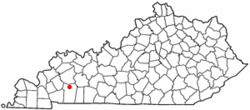
 Location of Crofton, Kentucky |
|
| Coordinates: 37°2′52″N 87°29′7″W / 37.04778°N 87.48528°WCoordinates: 37°2′52″N 87°29′7″W / 37.04778°N 87.48528°W | |
| Country | United States |
| State | Kentucky |
| County | Christian |
| Area | |
| • Total | 0.6 sq mi (1.6 km2) |
| • Land | 0.6 sq mi (1.6 km2) |
| • Water | 0.0 sq mi (0.0 km2) |
| Elevation | 597 ft (182 m) |
| Population (2010) | |
| • Total | 749 |
| • Density | 1,200/sq mi (463.5/km2) |
| Time zone | Central (CST) (UTC-6) |
| • Summer (DST) | CDT (UTC-5) |
| ZIP code | 42217 |
| Area code(s) | 270 & 364 |
| FIPS code | 21-18658 |
| GNIS feature ID | 0490363 |
| Website | www |
Crofton is a home rule-class city in Christian County, Kentucky, in the United States. The population was 749 at the 2010 census.
Crofton is part of the Clarksville, TN–KY Metropolitan Statistical Area.
Crofton had its start when the railroad was extended to that point. Incorporated in 1873, the city is named for pioneer James Croft, the original owner of the town site.
Crofton is located in northern Christian County at 37°2′52″N 87°29′7″W / 37.04778°N 87.48528°W (37.047752, -87.485260).U.S. Route 41 passes through the center of town as Madisonville Street, and the Pennyrile Parkway passes east of Crofton, with access from Exit 23. Hopkinsville, the Christian County seat, is 13 miles (21 km) to the south, and Madisonville is 22 miles (35 km) to the north.
According to the United States Census Bureau, Crofton has a total area of 0.6 square miles (1.6 km2), all land.
As of the census of 2000, there were 838 people, 353 households, and 234 families residing in the city. The population density was 1,318.6 people per square mile (505.6/km²). There were 380 housing units at an average density of 598.0 per square mile (229.2/km²). The racial makeup of the city was 85.44% White, 12.65% African American, 0.12% Native American or Alaska Native, and 1.79% from two or more races. Hispanics or Latinos of any race were 0.24% of the population.
...
Wikipedia
