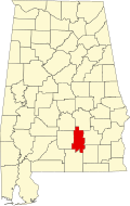
Crenshaw County, Alabama
| Crenshaw County, Alabama | |
|---|---|

Crenshaw County courthouse in Luverne
|
|
 Location in the U.S. state of Alabama |
|
 Alabama's location in the U.S. |
|
| Founded | November 30, 1866 |
| Named for | Anderson Crenshaw |
| Seat | Luverne |
| Largest city | Luverne |
| Area | |
| • Total | 611 sq mi (1,582 km2) |
| • Land | 609 sq mi (1,577 km2) |
| • Water | 2.1 sq mi (5 km2), 0.3% |
| Population (est.) | |
| • (2015) | 13,963 |
| • Density | 23/sq mi (9/km²) |
| Congressional district | 2nd |
| Time zone | Central: UTC-6/-5 |
| Website | crenshawcountyalonline |
|
Footnotes:
|
|
Footnotes:
Crenshaw County is a county of the U.S. state of Alabama. It is south from the Montgomery metropolitan area. As of the 2010 census, the population was 13,906. Its county seat is Luverne. Its name is in honor of an Alabama judge, Anderson Crenshaw.
Crenshaw County was established on November 30, 1866, by the Reconstruction era legislature. It was formed from parts of Butler, Coffee, Covington, Pike and Lowndes counties. While part of the coastal area, this county had relatively infertile soils, limiting agriculture, but enslaved African Americans were still used as workers.
It became a center of timbering in the piney wood, especially after the Montgomery and Florida Railroad Company constructed a line through here in 1886. This provided transport to markets for timber. It connected with Sprague Junction in Montgomery County, Alabama.
According to the U.S. Census Bureau, the county has a total area of 611 square miles (1,580 km2), of which 609 square miles (1,580 km2) is land and 2.1 square miles (5.4 km2) (0.3%) is water. Much of the land is covered by forests that are used for logging.
As of the census of 2000, there were 13,665 people, 5,577 households, and 3,892 families residing in the county. The population density was 22 people per square mile (9/km2). There were 6,644 housing units at an average density of 11 per square mile (4/km2). The racial makeup of the county was 73.82% White, 24.79% Black or African American, 0.37% Native American, 0.11% Asian, 0.01% Pacific Islander, 0.20% from other races, and 0.70% from two or more races. 0.64% of the population were Hispanic or Latino of any race.
...
Wikipedia
