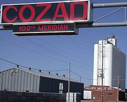
Cozad, Nebraska
| Cozad, Nebraska | |
|---|---|
| City | |

Sign marking the 100th meridian on U.S. Highway 30 in Cozad
|
|
 Location of Cozad, Nebraska |
|
| Coordinates: 40°51′44″N 99°59′3″W / 40.86222°N 99.98417°WCoordinates: 40°51′44″N 99°59′3″W / 40.86222°N 99.98417°W | |
| Country | United States |
| State | Nebraska |
| County | Dawson |
| Area | |
| • Total | 2.62 sq mi (6.79 km2) |
| • Land | 2.62 sq mi (6.79 km2) |
| • Water | 0 sq mi (0 km2) |
| Elevation | 2,490 ft (759 m) |
| Population (2010) | |
| • Total | 3,977 |
| • Estimate (2012) | 3,945 |
| • Density | 1,517.9/sq mi (586.1/km2) |
| Time zone | Central (CST) (UTC-6) |
| • Summer (DST) | CDT (UTC-5) |
| ZIP code | 69130 |
| Area code(s) | 308 |
| FIPS code | 31-11020 |
| GNIS feature ID | 0828431 |
| Website | http://cozadnebraska.net/ |
Cozad is a city in Dawson County, Nebraska, United States. The population was 3,977 at the 2010 census. The town is on the Great Plains of central Nebraska, along the Union Pacific Railroad and U.S. Highway 30, just north of the Platte River. The 100th meridian, which roughly marks the eastward boundary of the arid plains, passes just west of the town as is marked nearby on a prominent sign across U.S. Highway 30. In the early 1860s, it was a stop along the Pony Express.
Cozad is part of the Lexington, Nebraska Micropolitan Statistical Area.
Cozad was founded in 1873 by John J. Cozad, a native of Ohio, and named for him.
Cozad is located at 40°51′44″N 99°59′3″W / 40.86222°N 99.98417°W (40.862141, -99.984082).
According to the United States Census Bureau, the city has a total area of 2.62 square miles (6.79 km2), all of it land.
Cozad was settled by John Jackson Cozad, father of painter Robert Henri. Cozad also founded Cozaddale, Ohio, a small, unincorporated village 25 miles northeast of Cincinnati.
...
Wikipedia
