Coutances
| Coutances | |
|---|---|

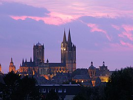
Coutances Cathedral
|
|
| Coordinates: 49°03′N 1°26′W / 49.05°N 1.44°WCoordinates: 49°03′N 1°26′W / 49.05°N 1.44°W | |
| Country | France |
| Region | Normandy |
| Department | Manche |
| Arrondissement | Coutances |
| Canton | Coutances |
| Area1 | 12.51 km2 (4.83 sq mi) |
| Population (1999)2 | 9,546 |
| • Density | 760/km2 (2,000/sq mi) |
| Time zone | CET (UTC+1) |
| • Summer (DST) | CEST (UTC+2) |
| INSEE/Postal code | 50147 / 50200 |
| Elevation | 12–150 m (39–492 ft) |
|
1 French Land Register data, which excludes lakes, ponds, glaciers > 1 km² (0.386 sq mi or 247 acres) and river estuaries. 2Population without double counting: residents of multiple communes (e.g., students and military personnel) only counted once. |
|
1 French Land Register data, which excludes lakes, ponds, glaciers > 1 km² (0.386 sq mi or 247 acres) and river estuaries.
Coutances (French pronunciation: [kutɑ̃s]) is a commune in the Manche department in Normandy in north-western France.
Capital of the Unelli, a Gaulish tribe, the town was given the name of Constantia in 298 during the reign of Roman emperor Constantius Chlorus. The surrounding region, called in Latin the pagus Constantinus subsequently became known as the Cotentin Peninsula.
The town was destroyed by invading Normans in 866, who later established settlements and incorporated the whole peninsula into the Duchy of Normandy in 933.
On July 17, 1944, during the Battle for Normandy in World War II, the city was bombed during the Allied offensive against the occupying Germans.
Coutances Cathedral is one of the major buildings of Norman architecture and contains a chapel and stained glass dedicated to Saint Marcouf. The bishop of Coutances exercised ecclesiastical jurisdiction over the Channel Islands until the Reformation, despite the secular division of Normandy in 1204. The final rupture occurred definitively in 1569.
...
Wikipedia


