County of Winzenburg
| Winzenburg | ||
|---|---|---|
| Ortsteil of Freden | ||

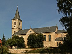
Nativity of Virgin Mary Church
|
||
|
||
| Coordinates: 51°56′N 09°56′E / 51.933°N 9.933°ECoordinates: 51°56′N 09°56′E / 51.933°N 9.933°E | ||
| Country | Germany | |
| State | Lower Saxony | |
| District | Hildesheim | |
| Municipality | Freden | |
| Area | ||
| • Total | 16.64 km2 (6.42 sq mi) | |
| Elevation | 178 m (584 ft) | |
| Population (2015-12-31) | ||
| • Total | 688 | |
| • Density | 41/km2 (110/sq mi) | |
| Time zone | CET/CEST (UTC+1/+2) | |
| Postal codes | 31088 | |
| Dialling codes | 05184 | |
| Vehicle registration | HI | |
Winzenburg is a village and a former municipality in the district of Hildesheim in Lower Saxony, Germany. Since 1 November 2016, it is part of the municipality Freden. It comprises four smaller communities, including the village of Winzenburg, which dates from the Middle Ages. Winzenburg is located in the Leinebergland to the north of Bad Gandersheim, between the national parks of the Harz and the Weserbergland, in Lower Saxony, Germany. The municipality (German: Gemeinde) was formed in March 1, 1974 from the four previously independent communities of Winzenburg, Schildhorst, Westerberg and Klump. It is near the small town of Freden.
Winzenburg is chiefly known for Winzenburg castle, a medieval castle now in ruins, which stands on a spur of the Sackwald. In the vicinity, it is also known for its man-made fishing ponds where one can either fish at one of the five ponds or eat fish at one of the Fischerhütte, the small nearby restaurants. Count Hermann II of Winzenburg built the castle at Schöneberg.
The hamlet of Westerberg began as a settlement next to a glassblower founded in 1744. Originally temporary because the property was rented, rather than owned, after the third 8-year extension of the lease, the settlement became permanent. Area clay pits later supported the production of bricks. They are now filled with water and are managed by the Freden sport fishing club.
Klump is below the Sauberg and started out as small farms and farmers who rented the land they lived and worked on.
...
Wikipedia


