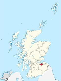
County of Edinburgh
|
|
|---|---|
 |
|
| Coordinates: 55°53′39″N 3°04′07″W / 55.89417°N 3.06861°WCoordinates: 55°53′39″N 3°04′07″W / 55.89417°N 3.06861°W | |
| Admin HQ | Dalkeith |
| Government | |
| • Body | Midlothian Council |
| • Control | SNP + GRN + Ind (council NOC) |
| • MPs |
|
| • MSPs |
|
| Area | |
| • Total | 136.6 sq mi (353.7 km2) |
| Area rank | Ranked 21st |
| Population (mid-2015 est.) | |
| • Total | 87,400 |
| • Rank | Ranked 26th |
| • Density | 640/sq mi (247/km2) |
| ONS code | S12000019 |
| ISO 3166 code | GB-MLN |
| Website | www |
Midlothian (/mɪdˈloʊðiən/; Scots: Midlowden, Scottish Gaelic: Meadhan Lodainn) is one of the 32 council areas of Scotland, UK. It borders Edinburgh, East Lothian and the Scottish Borders council areas.
Midlothian was also the name of a historic county formed in the Middle Ages. The county included Edinburgh and was formerly known as Edinburghshire, or more formally as the County of Edinburgh, until 1890. The historic county remains a lieutenancy area and a registration county for which purposes Edinburgh is included.
Midlothian Council area was created in 1996, under the Local Government etc. (Scotland) Act 1994, with the boundaries of the Midlothian district of the Lothian region. The district had been created in 1975, under the Local Government (Scotland) Act 1973, and it consisted of the local government county of Midlothian, minus the burgh of Musselburgh – with the areas of Inveresk, Wallyford and Whitecraig being lost to East Lothian, the Calders (East Calder, Midcalder and West Calder) and the Midlothian part of Livingston to West Lothian, Heriot and Stow parishes to the Ettrick and Lauderdale district of Borders Region, and Currie, Balerno, Ratho and Newbridge to Edinburgh.
...
Wikipedia
