County of Carnarvon (South Australia)
|
County of Carnarvon South Australia |
|||||||||||||
|---|---|---|---|---|---|---|---|---|---|---|---|---|---|

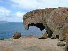
Remarkable Rocks formation in Flinders Chase within the Hundred of McDonald
|
|||||||||||||
| Coordinates | 35°48′29″S 137°17′04″E / 35.80792°S 137.284350°ECoordinates: 35°48′29″S 137°17′04″E / 35.80792°S 137.284350°E | ||||||||||||
| Established | 1874 | ||||||||||||
| LGA(s) | Kangaroo Island Council | ||||||||||||
| Region | Fleurieu and Kangaroo Island | ||||||||||||
|
|||||||||||||
| Footnotes | Coordinates | ||||||||||||
County of Carnarvon is a cadastral unit located in the Australian state of South Australia which covers the full extent of Kangaroo Island. It was proclaimed in 1874 by Governor Musgrave in response to the demand for agriculture land on Kangaroo Island.
The County of Carnarvon covers the full extent of Kangaroo Island and “all islands adjacent thereto.”
The County of Carnarvon was gazetted in 1874 in response to the demand for agricultural land on Kangaroo Island. The county was proclaimed by Anthony Musgrave, the ninth Governor of South Australia on 13 August 1874 along with the first of its constituent hundreds, the Hundred of Dudley. The country was named after Henry Herbert, 4th Earl of Carnarvon who served two terms as the British Secretary of State for the Colonies. The following twelve hundreds were proclaimed within the County between the years 1874 and 1960 - Dudley in 1874, Menzies in 1878, Haines in 1883, Cassini in 1884, MacGillivray in 1906, Seddon in 1908, Newland in 1909, Duncan in 1909, Ritchie in 1909, McDonald in 1910, Gosse in 1931, and Borda in 1960. A thirteenth hundred was proposed during the 1930s but was never proclaimed - the Hundred of Baudin (35°53′45″S 136°37′14″E / 35.895710°S 136.620470°E).
The hundreds located within the County of Carnarvon are laid out as follows (from west to east) - Borda, Gosse, Duncan, Cassini and Menzies overlooking the north coast of the island, MacDonald, Ritchie, Newland, Seddon and MacGillivray overlooking the south coast of the island, with Haines occupying the full extent of the island south of Nepean Bay and Dudley occupying the full extent of the Dudley Peninsula.
...
Wikipedia

