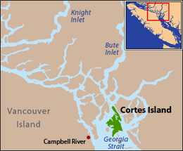
Cortes Island (British Columbia)

Cortes Island is located at the northern end of the Strait of Georgia.
|
|
| Geography | |
|---|---|
| Location | Strait of Georgia |
| Coordinates | 50°07′N 124°58′W / 50.117°N 124.967°W |
| Archipelago | Discovery Islands |
| Area | 130 km2 (50 sq mi) |
| Length | 25 km (15.5 mi) |
| Width | 13 km (8.1 mi) |
| Administration | |
| Demographics | |
| Population | 1042 (2006) |
| Ethnic groups | Wei We Kai, Kwiakah, Homalco and Klahoose First Nations |
Cortes Island is part of the traditional territories of the We Wai Kai, Kwiakah, Homalco, and Klahoose First Nations, with the office of the Klahoose First Nation located on the island. The island's southern tip is also part of the traditional territory of the Sliammon people.
Cortes, which is in the Sayward Land District, is 25 km (15.5 mi) long, 13 km (8.1 mi) wide, and 130 km2 (50 sq mi) in area. It has a population of 1,042 permanent residents (2006 census). Cortes Island lies within Electoral Area B of the Strathcona Regional District, which provides water and sewerage systems, fire protection, land use planning, parks, recreation, and emergency response.
Cortes Island is in the Sunshine Coast Forest District and the Vancouver Island Ministry of Environment's Vancouver Island Region. It is part of the North Island Provincial Electoral District. The Campbell River School District operates the Cortes Elementary / Jr. Secondary school on the island. Until recently there was also the Linnaea School, a non-traditional school which offered a different approach on education. It was closed due to a lack of students and funding. After the ninth grade, students must either switch to homeschooling or transfer to a school off the island.
The island was named in 1792 during the expedition of Galiano and Valdés, presumably after Hernán Cortés, the Spanish conqueror of Mexico.
...
Wikipedia
