Corippo
| Corippo | ||
|---|---|---|
 |
||
|
||
| Coordinates: 46°14′N 8°50′E / 46.233°N 8.833°ECoordinates: 46°14′N 8°50′E / 46.233°N 8.833°E | ||
| Country | Switzerland | |
| Canton | Ticino | |
| District | Locarno | |
| Government | ||
| • Mayor |
Sindaco Claudius Scettrini |
|
| Area | ||
| • Total | 7.73 km2 (2.98 sq mi) | |
| Elevation | 558 m (1,831 ft) | |
| Population (Dec 2015) | ||
| • Total | 13 | |
| • Density | 1.7/km2 (4.4/sq mi) | |
| Postal code | 6631 | |
| SFOS number | 5102 | |
| Surrounded by | Gordevio, Lavertezzo, Mergoscia, Vogorno | |
| Website |
www SFSO statistics |
|
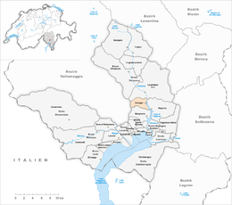
Corippo is a municipality in the district of Locarno in the canton of Ticino in Switzerland.
With a population of just 13, as of December 2015[update], it is the smallest municipality in Switzerland. Despite this, it possesses the trappings of communities many times its size: an official website (www.corippo.ch), its own coat of arms, a village church, a restaurant, and a mayor who leads a town council consisting of three local citizens. The village has maintained its status as an independent entity since its incorporation in 1822.
Corippo lies in the Verzasca valley some 12 kilometers (7.5 mi) from Locarno at the north end of the artificial Lake Vogorno, and 20 km from the border with Italy. The houses are built from the local Ticino granite with slate roofs and have changed little for several hundred years, leading the Italian writer Piero Bianconi to describe Corippo as "Verzasca's gentlest village". Its early 17th century Church of the Blessed Virgin Annunciata (later the Blessed Virgin Carmine) was extended in the late eighteenth century. Corippo's architectural value has caused the entire village centre to be placed under a conservation order, and in 1975 the European Architectural Heritage Congress named the village as an "exemplary model" for historical preservation.
Corippo was originally part of the larger parish and commune of Vogorno (though maintaining a certain degree of autonomy), before becoming a fully independent municipality in 1822. The village first became connected to the wider world in 1883 when a road was built linking it to the Verzasca valley road.
...
Wikipedia


