Corinda, Queensland
|
Corinda Brisbane, Queensland |
|||||||||||||
|---|---|---|---|---|---|---|---|---|---|---|---|---|---|

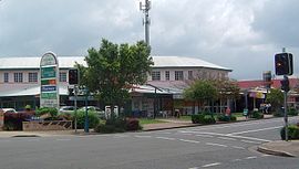
Shops along Oxley Road
|
|||||||||||||
| Coordinates | 27°32′S 152°59′E / 27.533°S 152.983°ECoordinates: 27°32′S 152°59′E / 27.533°S 152.983°E | ||||||||||||
| Population | 4,695 (2011 census) | ||||||||||||
| Postcode(s) | 4075 | ||||||||||||
| Location | 9 km (6 mi) from Brisbane GPO | ||||||||||||
| LGA(s) |
City of Brisbane (Tennyson Ward) |
||||||||||||
| State electorate(s) | Mount Ommaney | ||||||||||||
| Federal Division(s) | Oxley | ||||||||||||
|
|||||||||||||
Corinda is a suburb in Brisbane, Australia, located approximately 8.8 kilometres (5.5 mi) southwest of the Brisbane central business district. At the 2011 Australian Census the suburb recorded a population of 4,695.
It is believed that the name Corinda originates from a local cattle station owned by Sir Arthur Palmer, which he named after his Corinda pastoral station near Aramac.
In the 2011 census, the population of Corinda was 4,695, consisting of 52.3% female and 47.7% male. The median age of the Corinda population was 39 years, two years above the Australian median. 71.8% of people living in Corinda were born in Australia, similar to the national average of 69.8%. The other top responses for country of birth were England 4.9%, New Zealand 2.9%, India 1.1%, Philippines 0.8%, Germany 0.7%. 82.9% of people speak only English at home, while other languages include 0.9% Vietnamese, 0.8% Spanish, 0.8% Mandarin, 0.6% Cantonese, 0.6% Arabic.
Corinda was first settled in the 1860s as a small farming community. Among the original settlers was the Francis family who in 1862 purchased 21 acres, which extended from the Brisbane River to Francis Lookout, a local heritage listed landmark on Dewar Terrace. Francis Lookout survives to this day, and includes a small burial ground opened in 1862. Its ten graves include those of some of the pioneer settlers. The oldest of the graves is of Clement Francis who died in 1863. The lychgate, erected by Angela Francis, dates to 1902. Most of the original older-style Queenslander homes date back to the colonial period and were built high on the hills around the lookout.
The first rail line opened in 1874. A small commercial district on Oxley Road gradually grew around it. The Corinda School of Arts (now municipal library) is one of the earliest surviving buildings on this strip and is a small timber structure built in 1895. The commercial district rapidly developed after the 1920s. Many large bungalow styled homes were built on the floodplain toward Oxley Creek during this time.
The Corinda RSL was established in 1964 and now trades as the Sherwood Services Club. With the opening of Coles Supermarkets, the commercial centre has continued to develop and extend westward.
...
Wikipedia

