Cordón del Azufre
| Cordón del Azufre | |
|---|---|

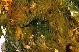
NASA Landsat composite image
|
|
| Highest point | |
| Elevation | 5,481 m (17,982 ft) |
| Coordinates | 25°20′S 68°30′W / 25.333°S 68.500°W |
| Geography | |
| Location | Argentina, Chile |
| Parent range | Andes |
| Geology | |
| Age of rock | 0.3 ± 0.3 mya |
| Mountain type | Complex volcano |
| Last eruption | Unknown |
Cordón del Azufre is a small, inactive complex volcano located in the Central Andes, at the border of Argentina and Chile. The centre contains a series of craters and lava flows covering a surface area of 60 square kilometres (23 sq mi). A western component with four craters aligned in a north–south direction on a 5-kilometre-long (3.1 mi) ridge forms the oldest part. The eastern component is formed by lava flows and craters in Argentina, and the youngest part la Moyra volcano in the western component generated a lava flow that advanced 6 kilometres (3.7 mi) westwards. Weakly porphyritic Andesite and dacite form the rocks of the volcano. No activity, including fumarolic activity, has been recorded at Cordón del Azufre, but the appearance (dark and pristine) and radiometric age (0.3 ± 0.3 mya K-Ar on the most recent flow) of the lava flows suggest a recent age.
It is located 300 kilometres (190 mi) east of the Chile Trench within the Puna where the volcanic arc intersects a probably deep seated structural area named the Archibarca corridor. Since the Eocene, underlying convergence and subduction of the Nazca plate at a speed of 6–7 centimetres per year (2.4–2.8 in/year) result in the volcanic activity of the Central Volcanic Zone (CVZ), the activity of fault zones and active deformation south of 23° S. Several large calderas lie in the CVZ, some of which (Galan, La Pacana) have erupted volumes of over 1,000 cubic kilometres (240 cu mi). The area is uninhabited and remote.
...
Wikipedia
