Copper Cliff
| Sudbury | |
|---|---|
| Former city | |

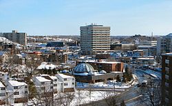
Downtown Sudbury.
|
|
| Country |
Canada |
| Province |
Ontario |
| City | Greater Sudbury |
| Wards | 1, 2, 4, 5, 8, 9, 10, 11, 12 |
| Incorporated (Town) | 1893 |
| Incorporated (City) | 1930 |
| Dissolved | 2000 |
| Government | |
| • City Councillors | Mark Signoretti, Michael Vagnini, Evelyn Dutrisac, Robert Kirwan, Al Sizer, Deb McIntosh, Fern Cormier, Lynne Reynolds, Joscelyne Landry-Altmann |
| • Governing Body | Greater Sudbury City Council |
| • MPs |
Paul Lefebvre (Liberal) Marc Serré (Liberal) |
| • MPPs |
France Gélinas (NDP) Glenn Thibeault (Liberal) |
| Population (2001)Statistics Canada | |
| • Total | 92,059 |
| Time zone | EST (UTC-5) |
| • Summer (DST) | EDT (UTC-4) |
| Postal Code FSA | P3A, P3B, P3C, P3E, P3G, P0M |
| Area code(s) | 705 |
This is a list of neighbourhoods in the urban core of Greater Sudbury, Ontario. This list includes only those neighbourhoods that fall within the pre-2001 city limits of Sudbury — for communities within the former suburban municipalities, see the articles Capreol, Nickel Centre, Onaping Falls, Rayside-Balfour, Valley East and Walden.
The Downtown of Sudbury is bounded by Ste-Anne Road/Davidson Street (1909) pg 12 to the north, Douglas Street (1909) pg 13 at Brady (1905) pg 6/Elgin Street at Howey Drive to the south, Kitchener Street to the east and Alder Street to the west, and includes one of the city's largest concentration of retail businesses and offices.
The downtown core was the city's original neighbourhood, which was filled with early settler log cabins, none of which currently exist.
An urban renewal project in the 1960s under expropriations saw the historic downtown Borgia Street (1890) pg 61 neighbourhood demolished in favour of a large shopping mall facility, now known as the Rainbow Centre, a realignment and expansion of Notre-Dame Avenue, a low rental tenement and a further expropriation for land to build Tom Davies Square, the city's modern city hall. A parcel of this land adjacent to the city hall was later donated by the city to the Sudbury Theatre Centre. The city also attracted national press attention in the 1970s for the creation of St. Andrew's Place, a multi purpose church facility, which incorporates a small chapel, retail space and a seniors' housing apartment tower, where two historic stone churches once stood.
With retail businesses in the city increasingly locating outside of the downtown core, particularly in the Four Corners, Kingsway and Lasalle Boulevard areas, the city has struggled in recent years to maintain a vibrant downtown. Recent projects have included the creation of Market Square, a farmers' and craft market, the redevelopment of the Rainbow Centre mall, streetscape beautification projects, and the creation of the Downtown Village Development Corporation, a not-for-profit organization that identifies and pursues development opportunities, creates partnerships, and advocates for and promotes initiatives that stimulate business and residential investment in Sudbury’s historic core. Although the city is in existence today because of the construction of the rail in this area of the province, at various times over the past 50 years, the city and community groups have proposed that the city purchase the CPR stockyards west of Elgin Street in order to expand the downtown area, although to date this has not been pursued. The farmers' market and historic CPR Ticket and Telegraph Building will be the site for Northern Ontario School of Architecture.
...
Wikipedia
