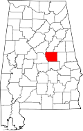
Coosa County, Alabama
| Coosa County, Alabama | |
|---|---|

County courthouse in Rockford
|
|
 Location in the U.S. state of Alabama |
|
 Alabama's location in the U.S. |
|
| Founded | December 18, 1832 |
| Seat | Rockford |
| Largest city | Goodwater |
| Area | |
| • Total | 666 sq mi (1,725 km2) |
| • Land | 651 sq mi (1,686 km2) |
| • Water | 15 sq mi (39 km2), 2.3% |
| Population (est.) | |
| • (2015) | 10,724 |
| • Density | 18/sq mi (7/km²) |
| Congressional district | 6th |
| Time zone | Central: UTC-6/-5 |
| Website | www |
|
Footnotes:
|
|
Footnotes:
Coosa County is a county of the U.S. state of Alabama. As of the 2010 census the population was 11,539. Its county seat is Rockford. Its name derives from a town of the Creek tribe and the Coosa River, which forms one of the county borders.
Coosa County is included in the Talladega-Sylacauga, AL Micropolitan Statistical Area, which is also included in the Birmingham-Hoover-Talladega, AL Combined Statistical Area.
The county was established on December 18, 1832, formed from parts of Montgomery and Shelby counties. It gained a small snippet from Montgomery County in 1837, and lost a portion to the south upon the creation of Elmore County in 1866.
According to the U.S. Census Bureau, the county has a total area of 666 square miles (1,720 km2), of which 651 square miles (1,690 km2) is land and 15 square miles (39 km2) (2.3%) is water.
From 2000 to 2003, Coosa County's growth rate of -5.8% made it the biggest percentage population loser among the state's 67 counties. Annette Jones Watters of the University of Alabama's Alabama State Data Center cited Coosa as one of eight counties to lose greater than 6% of its population from 2000 to early 2007.
...
Wikipedia
