Coonamble Shire Council
|
Coonamble Shire New South Wales |
|||||||||||||||
|---|---|---|---|---|---|---|---|---|---|---|---|---|---|---|---|

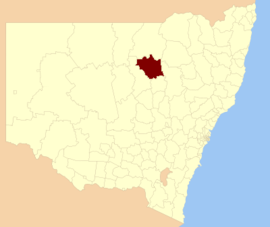
Location in New South Wales
|
|||||||||||||||
| Coordinates | 30°57′S 148°24′E / 30.950°S 148.400°ECoordinates: 30°57′S 148°24′E / 30.950°S 148.400°E | ||||||||||||||
| Population | 3,918 (2016 census) | ||||||||||||||
| • Density | 0.39472/km2 (1.02232/sq mi) | ||||||||||||||
| Established | 3 May 1880 | ||||||||||||||
| Area | 9,926 km2 (3,832.5 sq mi) | ||||||||||||||
| Mayor | Michael Webb (Unaligned) | ||||||||||||||
| Council seat | Coonamble | ||||||||||||||
| Region | Orana | ||||||||||||||
| State electorate(s) | Barwon | ||||||||||||||
| Federal Division(s) | Parkes | ||||||||||||||
| Website | Coonamble Shire | ||||||||||||||
|
|||||||||||||||
Coonamble Shire is a local government area in the Orana region of New South Wales, Australia. The Shire is located adjacent to the Castlereagh Highway and the Castlereagh River.
Coonamble Shire includes the towns of Coonamble, Gulargambone and Quambone.
The Mayor of Coonamble Shire Council is Cr. Michael Webb, who is unaligned with any political party.
Coonamble Shire Council is composed of seven councillors elected proportionally as a single ward. All councillors are elected for a fixed four-year term of office. The Mayor is elected by the councillors at the first meeting of the Council. The most recent election was held on 10 September 2016, and the makeup of the Council is as follows:
The current Council, elected in 2016, in order of election, is:
...
Wikipedia
