Castlereagh Highway
|
Castlereagh Highway Queensland–New South Wales |
|
|---|---|
 |
|
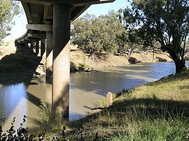
| Dick O'Brien Bridge (1991) carrying Castlereagh Highway over Barwon River, Walgett, NSW. | |
 |
|
| Type | Highway |
| Length | 790 km (491 mi) |
| Route number(s) |
|
| Former route number |
|
| North end | |
|
|
| South end | |
| Major settlements | Hebel, Walgett, Gilgandra, Mudgee, Cullen Bullen |
|
Highways in Australia National Highway • Freeways in Australia Highways in Queensland Highways in New South Wales |
|
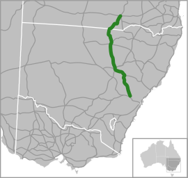
The Castlereagh Highway is a 790-kilometre (490 mi) state highway located in New South Wales and Queensland, Australia. The highway's northern terminus is at a junction with the Carnarvon Highway, south of St George, Queensland. Its southern terminus is at a junction with the Great Western Highway at Marrangaroo, 10 kilometres (6.2 mi) north of Lithgow. From north the south the highway traverses South West Queensland and the North West Slopes, Orana, and Central West regions of New South Wales.
The highway is part of the 'Great Inland Way' linking Sydney and Cairns, and provides all-weather access to rugged black opal country of Lightning Ridge.
The Castlereagh Highway was named in 1954 after the Castlereagh River – which it parallels for most of its journey north from Gilgandra – with the river named in honour of Lord Castlereagh.
The highway was extended past Gilgandra to include state route 86 in October 1997. As such the Castlereagh Highway starts just outside Lithgow at a junction with the Great Western Highway and runs in a north-westerly direction through Ilford and the junctions of Bathurst-Ilford Road and Bylong Valley Way, through the regional centre of Mudgee and Gulgong. From there the Castlereagh Highway is concurrent with the Golden Highway through Dunedoo, then branches off in Dunedoo, continuing past Gilgandra until it reaches the Queensland border via Walgett at Hebel. From there it continues to the outskirts of St George where it terminates with the Carnarvon Highway.
...
Wikipedia
