Coolidge, Kansas
| Coolidge, Kansas | |
|---|---|
| City | |

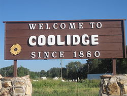
Welcome Sign (2010)
|
|
 Location within Hamilton County and Kansas |
|
 KDOT map of Hamilton County (legend) |
|
| Coordinates: 38°2′32″N 102°0′37″W / 38.04222°N 102.01028°WCoordinates: 38°2′32″N 102°0′37″W / 38.04222°N 102.01028°W | |
| Country | United States |
| State | Kansas |
| County | Hamilton |
| Area | |
| • Total | 0.46 sq mi (1.19 km2) |
| • Land | 0.46 sq mi (1.19 km2) |
| • Water | 0 sq mi (0 km2) |
| Elevation | 3,356 ft (1,023 m) |
| Population (2010) | |
| • Total | 95 |
| • Estimate (2015) | 88 |
| • Density | 210/sq mi (80/km2) |
| Time zone | Mountain (MST) (UTC-7) |
| • Summer (DST) | MDT (UTC-6) |
| ZIP code | 67836 |
| Area code | 620 |
| FIPS code | 20-15400 |
| GNIS feature ID | 0485265 |
Coolidge is a city in Hamilton County, Kansas, United States. As of the 2010 census, the city population was 95.
The city of Coolidge was named after Thomas Jefferson Coolidge, the former president of the Atchison, Topeka and Santa Fe Railway.
The first post office in Coolidge was established in July 1881.
Coolidge is located at 38°2′32″N 102°0′37″W / 38.04222°N 102.01028°W (38.042318, -102.010210). According to the United States Census Bureau, the city has a total area of 0.46 square miles (1.19 km2), all of it land.
According to the Köppen Climate Classification system, Coolidge has a semi-arid climate, abbreviated "BSk" on climate maps.
As of the census of 2010, there were 95 people, 43 households, and 26 families residing in the city. The population density was 206.5 inhabitants per square mile (79.7/km2). There were 49 housing units at an average density of 106.5 per square mile (41.1/km2). The racial makeup of the city was 82.1% White and 17.9% from other races. Hispanic or Latino of any race were 33.7% of the population.
...
Wikipedia
