Conques
| Conques | ||
|---|---|---|

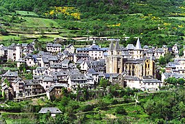
A general view of Conques
|
||
|
||
| Coordinates: 44°36′01″N 2°23′50″E / 44.6003°N 2.3972°ECoordinates: 44°36′01″N 2°23′50″E / 44.6003°N 2.3972°E | ||
| Country | France | |
| Region | Occitanie | |
| Department | Aveyron | |
| Arrondissement | Rodez | |
| Canton | Lot et Dourdou | |
| Government | ||
| • Mayor (2008–2014) | Philippe Varsi | |
| Area1 | 30.51 km2 (11.78 sq mi) | |
| Population (2008)2 | 281 | |
| • Density | 9.2/km2 (24/sq mi) | |
| Time zone | CET (UTC+1) | |
| • Summer (DST) | CEST (UTC+2) | |
| INSEE/Postal code | 12076 / 12320 | |
| Elevation | 221–663 m (725–2,175 ft) (avg. 442 m or 1,450 ft) |
|
|
1 French Land Register data, which excludes lakes, ponds, glaciers > 1 km² (0.386 sq mi or 247 acres) and river estuaries. 2Population without double counting: residents of multiple communes (e.g., students and military personnel) only counted once. |
||
1 French Land Register data, which excludes lakes, ponds, glaciers > 1 km² (0.386 sq mi or 247 acres) and river estuaries.
Conques (Concas in Occitan) is a former commune in the Aveyron department in southern France, in the Occitanie region. On 1 January 2016, it was merged into the new commune of Conques-en-Rouergue.
The village is located at the confluence of the Dourdou de Conques and Ouche rivers. It is built on a hillside and has classic narrow Medieval streets. As a result, large vehicles (such as buses) cannot enter the historic town centre but must park outside. Consequently, most day visitors enter on foot. The town was largely passed by in the nineteenth century, and was saved from oblivion by the efforts of a small number of dedicated people. As a result, the historic core of the town has very little construction dating from between 1800 and 1950, leaving the medieval structures remarkably intact. The roads have been paved, and modern-day utility lines are buried.
The town is situated in a valley. Its name originates from Old French conche basin (Latin concha shell).
The St. Foy abbey-church in Conques was a popular stop for pilgrims on their way to Santiago de Compostela, in what is now Spain. The main draw for medieval pilgrims at Conques were the remains of St. Foy, a martyred young woman from the fourth century.
The original monastery building at Conques was an eighth-century oratory built by monks fleeing the Saracens in Spain. The original chapel was destroyed in the eleventh century in order to facilitate the creation of a much larger church as the arrival of the relics of St. Foy caused the pilgrimage route to shift from Agen to Conques. The second phase of construction, which was completed by the end of the eleventh-century, included the building of the five radiating chapels, the ambulatory with a lower roof, the choir without the gallery and the nave without the galleries. The third phase of construction, which was completed early in the twelfth-century, was inspired by the churches of Toulouse and Santiago Compostela. Like most pilgrimage churches Conques is a basilica plan that has been modified into a cruciform plan. Galleries were added over the aisle and the roof was raised over the transept and choir to allow people to circulate at the gallery level. The western aisle was also added to allow for increased pilgrim traffic. The exterior length of the church is 59 meters. The interior length is 56 meters. the width of each transept is 4 meters. The height of the crossing tower is 26.40 meters tall.
...
Wikipedia


