Columbiana, OH
| Columbiana, Ohio | |
|---|---|
| City | |

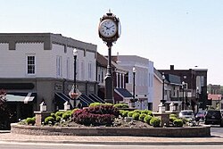
Downtown Columbiana
|
|
| Motto: "The City with the Small-Town Heart" | |
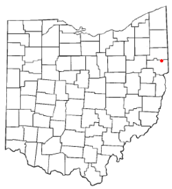
 Location of Columbiana, Ohio |
|
 Location of Columbiana in Columbiana County |
|
| Coordinates: 40°53′8″N 80°41′18″W / 40.88556°N 80.68833°WCoordinates: 40°53′8″N 80°41′18″W / 40.88556°N 80.68833°W | |
| Country | United States |
| State | Ohio |
| Counties | Columbiana, Mahoning |
| Government | |
| • Type | Council-Manager |
| • City Manager | Lance Willard |
| • Mayor | Bryan Blakeman |
| Area | |
| • Total | 6.14 sq mi (15.90 km2) |
| • Land | 6.00 sq mi (15.54 km2) |
| • Water | 0.14 sq mi (0.36 km2) |
| Elevation | 1,158 ft (353 m) |
| Population (2010) | |
| • Total | 6,384 |
| • Estimate (2016) | 6,257 |
| • Density | 1,064.0/sq mi (410.8/km2) |
| Time zone | Eastern (EST) (UTC-5) |
| • Summer (DST) | EDT (UTC-4) |
| ZIP code | 44408 |
| Area code(s) | 330, 234 |
| FIPS code | 39-17036 |
| GNIS feature ID | 1060989 |
| Website | www |
Columbiana is a city in Columbiana and Mahoning counties in the U.S. state of Ohio. The population was 6,384 at the 2010 census.
The larger portion of the city, located in Columbiana County, is part of the Salem, OH Micropolitan Statistical Area, while the smaller Mahoning County portion is part of the Youngstown-Warren-Boardman, OH-PA Metropolitan Statistical Area.
Columbiana was laid out by Joshua Dixon in 1805. The city takes its name from Columbiana County, which itself is a portmanteau of Christopher Columbus and Queen Anne. Columbiana was incorporated as a village in 1837. When founded, the village had a central location in Columbiana County; however, the formation of Mahoning County in 1846 caused it to run the border between the two new counties. The village officially became a city in 2000.
Columbiana is located at 40°53′8″N 80°41′18″W / 40.88556°N 80.68833°W (40.885579, -80.688327).
According to the United States Census Bureau, the city has a total area of 6.14 square miles (15.90 km2), of which 6.00 square miles (15.54 km2) is land and 0.14 square miles (0.36 km2) is water.
As of the census of 2010, there were 6,384 people, 2,881 households, and 1,763 families residing in the city. The population density was 1,064.0 inhabitants per square mile (410.8/km2). There were 3,181 housing units at an average density of 530.2 per square mile (204.7/km2). The racial makeup of the city was 97.7% White, 0.6% African American, 0.5% Asian, 0.4% from other races, and 0.8% from two or more races. Hispanic or Latino people of any race were 1.0% of the population.
...
Wikipedia
