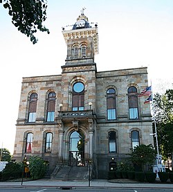
Columbiana County, Ohio
| Columbiana County, Ohio | |||
|---|---|---|---|

|
|||
|
|||
 Location in the U.S. state of Ohio |
|||
 Ohio's location in the U.S. |
|||
| Founded | May 1, 1803 | ||
| Named for | Christopher Columbus | ||
| Seat | Lisbon | ||
| Largest city | Salem | ||
| Area | |||
| • Total | 535 sq mi (1,386 km2) | ||
| • Land | 532 sq mi (1,378 km2) | ||
| • Water | 2.8 sq mi (7 km2), 0.5% | ||
| Population | |||
| • (2010) | 107,841 | ||
| • Density | 203/sq mi (78/km²) | ||
| Congressional district | 6th | ||
| Time zone | Eastern: UTC-5/-4 | ||
| Website | www |
||
Columbiana County is a county located in the U.S. state of Ohio. As of the 2010 census, the population was 107,841. The county seat is Lisbon. The county name is derived from the explorer of the Americas, Christopher Columbus.
Columbiana County comprises the Salem, OH Micropolitan Statistical Area, which is also included in the larger Youngstown-Warren, OH-PA Combined Statistical Area. It also abuts the Pittsburgh area directly to the east and south. Pittsburgh International Airport is only a 35-minute drive southeast of East Liverpool, while Downtown Pittsburgh is only 50 minutes away.
Due to its location, Columbiana County is traditionally considered part of both Appalachian Ohio and the Steel Valley, sharing more in common culturally with neighboring Western Pennsylvania and West Virginia (both of which are also part of Appalachia) than much of Northeast Ohio in general. Officially considered part of the Youngstown television market, the Steubenville television market regularly reports in the area as well.
The principal historic Indian tribes in the area were the Wyandots, Mingoes, and Delawares. Throughout the second half of the 18th century white explorers, starting with Christopher Gist in 1750, came to the area. George Washington, while engaged in land examinations, camped in the area of present-day East Liverpool in 1774.
...
Wikipedia


