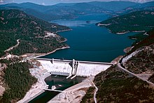
Columbia River Treaty
| Duncan Dam | |
|---|---|
 |
|
| Country | Canada |
| Location | Howser, British Columbia |
| Coordinates | 50°15′03″N 116°57′03″W / 50.25083°N 116.95083°W |
| Dam and spillways | |
| Impounds | Duncan River |
| Reservoir | |
| Creates | Duncan Lake |
| Total capacity | 1.70 km3 (1,380,000 acre·ft) |
| Hugh Keenleyside Dam | |
|---|---|
 |
|
| Country | Canada |
| Location | Castlegar, British Columbia |
| Coordinates | 49°20′22″N 117°46′19″W / 49.33944°N 117.77194°W |
| Dam and spillways | |
| Impounds | Columbia River |
| Reservoir | |
| Creates | Arrow Lakes |
| Total capacity | 8.76 km3 (7,100,000 acre·ft) |
| Mica Dam | |
|---|---|
 |
|
| Country | Canada |
| Location | Mica Creek, British Columbia |
| Coordinates | 52°04′40″N 118°33′59″W / 52.07778°N 118.56639°W |
| Dam and spillways | |
| Impounds | Columbia River |
| Reservoir | |
| Creates | Kinbasket Lake |
| Total capacity | 15 km3 (12,000,000 acre·ft) |
| Libby Dam | |
|---|---|
 |
|
| Country | United States |
| Location | Libby, Montana |
| Coordinates | 48°24′37″N 115°18′54″W / 48.41028°N 115.31500°W |
| Dam and spillways | |
| Impounds | Kootenai River |
| Reservoir | |
| Creates | Lake Koocanusa |
| Total capacity | 7.43 km3 (6,020,000 acre·ft) |
Canadian waterways in red
United States waterways in blue
Columbia River Treaty dams in bold
Canal Plant Agreement dams in italic
The Columbia River Treaty is a 1964 agreement between Canada and the United States on the development and operation of dams in the upper Columbia River basin for power and flood control benefits in both countries. Four dams were constructed under this treaty: three in Canada (Duncan Dam, Mica Dam, Keenleyside Dam) and one in the United States (Libby Dam). The treaty provided for the sharing with Canada of one-half of the downstream U.S. power and flood benefits, and allows the operation of Treaty storage for other benefits. The long-term impacts of the treaty have been mixed: while the dams have provided enormous economic benefits to British Columbia and the U.S. Pacific Northwest through hydroelectric generation and flood control, there are longstanding concerns regarding social and economic impacts to the local communities, and the environmental effects associated with the construction and operation of large dams.
In 1944, the Canadian and U.S. governments agreed to begin studying the potential for joint development of dams in the Columbia River basin. Planning efforts were slow until a 1948 Columbia River flood caused extensive damage from Trail, British Columbia, to near Astoria, Oregon, completely destroying Vanport, the second largest city in Oregon. The increased interest in flood protection and the growing need for power development initiated 11 years of discussion and alternative proposals for construction of dams in Canada. In 1959, the governments issued a report that recommended principles for negotiating an agreement and apportioning the costs and benefits. Formal negotiations began in February 1960 and the Treaty was signed 17 January 1961 by Prime Minister Diefenbaker and President Eisenhower. The treaty was not implemented, however, until over three years later due to difficulties in creating arrangements for funding the construction of the Canadian dams and marketing the electrical power owed to Canada which was surplus to Canadian needs during the early treaty years. A Treaty Protocol and a Canada-B.C. agreement were signed in January 1964 that limited and clarified many treaty provisions, defined rights and obligations between the British Columbia and Canadian governments, and allowed for the sale of the Canadian Entitlement to downstream U.S. power benefits. Instruments of ratification were exchanged and the treaty was implemented on 16 September 1964.
...
Wikipedia
