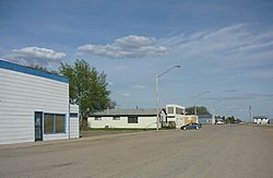
Colonsay, Saskatchewan
| Colonsay | |
|---|---|
| Town | |

Railway Avenue
|
|
| Motto: "Isle of the Prairies" | |
| Location of Colonsay in Saskatchewan | |
| Coordinates: 51°59′N 105°53′W / 51.983°N 105.883°W | |
| Country | Canada |
| Province | Saskatchewan |
| Rural Municipalities (R.M.) | Colonsay No. 342, Saskatchewan |
| Post office Founded | 1908-05-21 |
| Village established | 1907 |
| Town incorporated | 1910 |
| Government | |
| • Mayor | James Gray |
| • Federal Electoral District Blackstrap (historical riding Rosthern) M.P. | Lynne Yelich |
| • provincial electoral districts Constituency of Humboldt M.L.A. | Donna Harpauer |
| Area | |
| • Total | 6.4 km2 (2.46 sq mi) |
| Population (2011) | |
| • Total | 475 |
| • Density | 193.1/km2 (500/sq mi) |
| Website | Town Website |
Colonsay /kəˈlɒnziː/ is a town in the rural municipality of Colonsay No. 342, Saskatchewan, in the Canadian province of Saskatchewan. Colonsay is located on Highway 16 (the Yellowhead Highway part of the Trans-Canada Highway) running east-west in central Saskatchewan near the intersection with Highway 2.
Colonsay derived its name from the Inner Hebrides Scottish island of Colonsay All the streets in the village are also named after islands located along the west coast of Scotland.
Colonsay experienced a record setting 167-day-long frost-free period in 1978, which was, to the dismay of a number of residents, still not a long enough growing season for yams or sweet potatoes.
The ship U-Sea Colonsay is named after the local potash mine.
The main economy of the area is agriculture featuring grain crops such as wheat, canola, barley, oats, rye, as well as lentils and peas. Livestock raised in the vicinity are cattle, hogs, sheep, and buffalo. The potash mine of Colonsay was first named Potash Corporation of Saskatchewan, Colonsay, IMC Potash Colonsay and is now Mosaic Potash Colonsay. Potash is mined and sold to crop nutrient manufacturers for fertilizer, as well as for use as icemelter ingredient and water softener regenerant.
...
Wikipedia


