Colonsay
| Gaelic name | Colbhasa |
|---|---|
| Pronunciation | [kʰɔlˠ̪ɔ.əs̪ə] |
| Norse name | Colonsey |
| Meaning of name | Old Norse for 'Columba's isle' |
| Location | |
|
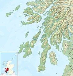
Colonsay shown within Argyll and Bute
|
|
| OS grid reference | NR382938 |
| Coordinates | 56°04′N 6°13′W / 56.06°N 6.21°W |
| Physical geography | |
| Island group | Islay |
| Area | 4,074 hectares (15.7 sq mi) |
| Area rank | 26 |
| Highest elevation | 143 metres (469 ft) |
| Administration | |
| Sovereign state | United Kingdom |
| Country | Scotland |
| Council area | Argyll and Bute |
| Demographics | |
| Population | 124 |
| Population rank | 44 |
| Population density | 2.7 people/km2 |
| Largest settlement | Scalasaig |
| References | |
|
Argyll and Bute
|
|
| Location | Scalasaig Isle of Colonsay Argyll and Bute Scotland United Kingdom |
|---|---|
| Coordinates | 56°04′01″N 6°10′54″W / 56.066846°N 6.181805°W |
| Year first constructed | 1903 (first) 1957 (second) |
| Year first lit | 2003 (current) |
| Automated | 2003 |
| Deactivated | 1957 (first) 2003 (second) |
| Foundation | reinforced concrete |
| Construction | metal skeletal tower |
| Tower shape | square parallelepiped tower covered by aluminium panels with balcony and light on the top |
| Markings / pattern | white tower |
| Height | 8 metres (26 ft) |
| Focal height | 5 metres (16 ft) |
| Light source | solar power |
| Characteristic | Fl (2) w 10s. |
| Admiralty number | A4200 |
| NGA number | 4140 |
| ARLHS number | SCO-202 |
| Managing agent | Northern Lighthouse Board |
Colonsay (Scottish Gaelic: Colbhasa) is an island in the Inner Hebrides of Scotland, located north of Islay and south of Mull. The ancestral home of Clan Macfie and the Colonsay branch of Clan MacNeil, it is in the council area of Argyll and Bute and has an area of 4,074 hectares (15.7 sq mi). Aligned on a south-west to north-east axis, it measures 8 miles (13 km) in length and reaches 3 miles (4.8 km) at its widest point.
Although Colonsay appears bare and somewhat forbidding on approach from the sea, its landscape is varied, with several sandy beaches, and a sheltered and fertile interior, unusually well-wooded for a Hebridean island. It is linked by a tidal causeway (called The Strand) to Oronsay. The highest point on the island is Carnan Eoin, 143 metres above sea level.
The Colonsay Group, which takes its name from the island, is an estimated 5,000 m thick sequence of mildly metamorphosed Neoproterozoic sedimentary rocks that also outcrop on the islands of Islay and Oronsay and the surrounding seabed. The sequence has been correlated with the Grampian Group, the oldest part of the Dalradian Supergroup.
In 1995 evidence of large-scale Mesolithic nut shelling, some 9000 years ago, was found in a midden pit at Staosnaig on the island's sheltered east coast, in a large, shallow pit full of the remains of hundreds of thousands of burned hazelnut shells. Hazelnuts have been found on other Mesolithic sites, but rarely in such quantities or concentrated in one pit. The nuts were radiocarbon dated to 7720+/-110BP, which calibrates to circa 7000 BC. Similar sites in Britain and its dependencies are known only at Farnham in Surrey and Cass ny Hawin on the Isle of Man.
...
Wikipedia


