Col du Galibier
| Col du Galibier | |
|---|---|

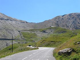
Col du Galibier (North view)
|
|
| Elevation | 2,645 m (8,678 ft) |
| Traversed by | D902B |
| Location | Savoie/Hautes-Alpes, France |
| Range | Graian Alps |
| Coordinates | 45°03′50.4″N 06°24′28.8″E / 45.064000°N 6.408000°ECoordinates: 45°03′50.4″N 06°24′28.8″E / 45.064000°N 6.408000°E |
|
Location of Col du Galibier
|
|
Col du Galibier (el. 2,645 metres (8,678 ft)) is a mountain pass in the southern region of the French Dauphiné Alps near Grenoble. It is the ninth highest paved road in the Alps and the sixth highest mountain pass. It is often the highest point of the Tour de France.
It connects Saint-Michel-de-Maurienne and Briançon via the col du Télégraphe and the Col du Lautaret. The pass is closed during the winter. It is located between the massif d'Arvan-Villards and the massif des Cerces, taking its name from the secondary chain of mountains known as the Galibier.
Before 1976, the tunnel was the only point of passage at the top, at an altitude of 2556 m. The tunnel was closed for restoration until 2002, and a new road was constructed over the summit. The re-opened tunnel is a single lane controlled by traffic lights, which are among the highest such installations in Europe.
In 1876 first passable road could be opened between Maurienne and Briançonnais respectively Oisans. In the north passroad begins in Valloire, this place is only reachable via Col du Télégraphe which is before Galibier and connects Saint-Michel-de-Maurienne with Valloire. In the south the road beginns at a level of 2,057 m Col du Lautaret, which connects Grenoble in the west with Briançon in the east. Highest point of this road was at an altitude of 2,658 m, 16 meters higher than nowadays. Road between Col du Lautaret is 24,5 kilometers long, 16 kilometers is the northern part, 8,5 kilometers is the south part. Road over Galibier was first a natural road and later asphalted.
...
Wikipedia

