Col de la Bonette
| Col de la Bonette | |
|---|---|

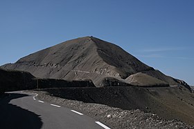
Cime de la Bonette, viewed from the northern ascent from Jausiers. The Col de la Bonette is marked by the gap in the centre of the picture, while the circle road takes a loop up and around the Cime de la Bonette, before joining the col behind the ridge.
|
|
| Elevation | 2,715 metres (8,907 ft) or 2,802 metres (9,193 ft) (Cime de la Bonette) |
| Traversed by | D64 |
| Location | Alpes-Maritimes/Alpes-de-Haute-Provence, France |
| Range | Alps |
| Coordinates | 44°19′37.2″N 06°48′25.2″E / 44.327000°N 6.807000°ECoordinates: 44°19′37.2″N 06°48′25.2″E / 44.327000°N 6.807000°E |
| Location of Col de la Bonette | |
Col de la Bonette (el. 2,715 metres (8,907 ft)) is a high mountain pass in the French Alps, near the border with Italy. It is situated within the Mercantour National Park on the border of the departments of Alpes-Maritimes and Alpes-de-Haute-Provence. The road over the col is the seventh highest paved road in the Alps.
The passage over the Col de la Bonette is often mistakenly referred to as the Col de Restefond, and in the 2008 Tour de France the summit was referred to as the Cime de la Bonette-Restefond. Stage 16 of the tour approached the summit from Saint-Étienne-de-Tinée (south-east), and after reaching the Col de la Bonette, took a loop round the Cime de la Bonette reaching the summit of 2,802 m (9,193 ft), which is the highest point reached by the Tour de France, before re-passing the Col de la Bonette. On the descent to Jausiers, the actual Col de Restefond was then passed on the right approximately 1 km from the summit.
The two kilometre long teardrop shaped loop around the Cime de la Bonette peak (2,860 m (9,380 ft)) from either side of the pass is the highest paved through route in the Alps.
A signpost at the foot of the climb makes the claim "Col de la Bonette - Restefond, 2802 m above sea level, highest road in Europe". This claim is incorrect for various reasons. The actual Col de la Bonette rises to 2,715 m (8,907 ft), but there are three Alpine road passes whose altitudes are higher: Col de l'Iseran (2,770 m (9,090 ft)), Stelvio Pass (2,757 m (9,045 ft)) and Col Agnel (2,744 m (9,003 ft)). There is also the road to Veleta (Sierra Nevada), Spain (near Granada) which reaches 3,392 m (11,129 ft) but it is not a through road.
...
Wikipedia

