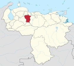
Cojedes (state)
| Cojedes | ||
|---|---|---|
| State of Venezuela | ||
|
||
| Motto: Ad sum English: I am here |
||
| Anthem: Himno del Estado Cojedes | ||
 Location within Venezuela |
||
| Coordinates: 9°22′N 68°19′W / 9.36°N 68.32°WCoordinates: 9°22′N 68°19′W / 9.36°N 68.32°W | ||
| Country | Venezuela | |
| Created | 1864 | |
| Capital | San Carlos | |
| Government | ||
| • Governor | Erika Farías (2012–2016) | |
| Area | ||
| • Total | 14,800 km2 (5,700 sq mi) | |
| Area rank | 13th | |
| 1.62% of Venezuela | ||
| Population (2011 census) | ||
| • Total | 323,165 | |
| • Rank | 22nd | |
| 1.14% of Venezuela | ||
| Time zone | UTC-04:30 | |
| ISO 3166 code | VE-H | |
| Emblematic tree | Apamate (Tabebuia rosea) | |
| Website | www |
|
Cojedes State (Spanish: Estado Cojedes, IPA: [esˈtaðo koˈxeðes]) is one of the 23 states of Venezuela. The state capital is San Carlos.
Cojedes State covers a total surface area of 14,800 km² and, in 2011, had a census population of 323,165.
Native Americans from the Orinoco region kept moving through this region to colonize or trade with the regions around the Tacarigua Lake (the native name for Lake Valencia).
Fray Cirilo Bautista of Sevilla founded Santa Clara de Caramacate in 1750. Bishop Mariano Martí wrote some of the first reports about the area in 1760. That year missionaries Fray Gabriel de San Lucas and Fray Salvador of Cádiz founded the city of San Carlos. The original name was San Carlos de Austria. Nuestra Señora de la Chiquinquirá of El Tinaco was founded by Fray Pablo de Orichuela on the same year. El Pao was founded one year later, in 1661. The towns and the areas around them became cantons under jurisdiction of the Province of Caracas.
After the independence, the territory became part of Carabobo Province, one of the 11 Provinces of Venezuela at independence.
According to the 2011 Census, the racial composition of the population was:
...
Wikipedia


