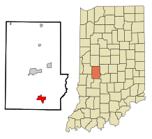
Cloverdale, Indiana
| Cloverdale, Indiana | |
|---|---|
| Town | |
 |
|
 Location in the state of Indiana |
|
| Coordinates: 39°30′55″N 86°48′9″W / 39.51528°N 86.80250°WCoordinates: 39°30′55″N 86°48′9″W / 39.51528°N 86.80250°W | |
| Country | United States |
| State | Indiana |
| County | Putnam |
| Township | Cloverdale, Warren |
| Area | |
| • Total | 3.52 sq mi (9.12 km2) |
| • Land | 3.46 sq mi (8.96 km2) |
| • Water | 0.06 sq mi (0.16 km2) |
| Elevation | 820 ft (250 m) |
| Population (2010) | |
| • Total | 2,172 |
| • Estimate (2012) | 2,144 |
| • Density | 627.7/sq mi (242.4/km2) |
| Time zone | EST (UTC-5) |
| • Summer (DST) | EST (UTC-5) |
| ZIP code | 46120 |
| Area code(s) | 765 |
| FIPS code | 18-13852 |
| GNIS feature ID | 432688 |
| Website | http://www.cloverdale.in.us |
Cloverdale is a town in Cloverdale and Warren townships, Putnam County, in the U.S. state of Indiana. The population was 2,172 at the 2010 census.
Cloverdale was laid out in 1839. The town was so named on account of the abundance of clover and dales near the original town site. A post office has been in operation at Cloverdale since 1836.
Cloverdale is located at 39°30′55″N 86°48′9″W / 39.51528°N 86.80250°W (39.515345, -86.802559).
According to the 2010 census, Cloverdale has a total area of 3.52 square miles (9.12 km2), of which 3.46 square miles (8.96 km2) (or 98.3%) is land and 0.06 square miles (0.16 km2) (or 1.7%) is water.
As of the census of 2010, there were 2,172 people, 885 households, and 608 families residing in the town. The population density was 627.7 inhabitants per square mile (242.4/km2). There were 1,001 housing units at an average density of 289.3 per square mile (111.7/km2). The racial makeup of the town was 97.4% White, 0.6% African American, 0.3% Native American, 0.3% Asian, 0.2% from other races, and 1.2% from two or more races. Hispanic or Latino of any race were 0.9% of the population.
...
Wikipedia
