Closter, New Jersey
| Closter, New Jersey | |
|---|---|
| Borough | |
| Borough of Closter | |

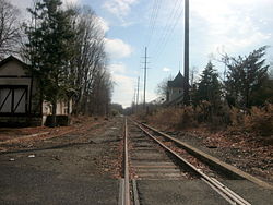
The former station depot of the Erie Railroad's Northern Branch as seen from the crossing of County Route 502 (High Street) in Closter
|
|
| Nickname(s): "Hub of the Northern Valley" | |
 Map highlighting Closter's location within Bergen County. Inset: Bergen County's location within New Jersey |
|
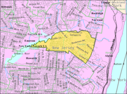
 Census Bureau map of Closter, New Jersey |
|
| Coordinates: 40°58′22″N 73°57′37″W / 40.97289°N 73.960315°WCoordinates: 40°58′22″N 73°57′37″W / 40.97289°N 73.960315°W | |
| Country | |
| State |
|
| County | Bergen |
| Incorporated | January 1, 1904 |
| Government | |
| • Type | Borough |
| • Body | Borough Council |
| • Mayor | John C. Glidden Jr. (R, term ends December 31, 2018) |
| • Administrator | Jonathan DeJoseph |
| • Clerk | Loretta Castano |
| Area | |
| • Total | 3.295 sq mi (8.535 km2) |
| • Land | 3.164 sq mi (8.196 km2) |
| • Water | 0.131 sq mi (0.339 km2) 3.98% |
| Area rank | 323rd of 566 in state 24th of 70 in county |
| Elevation | 39 ft (12 m) |
| Population (2010 Census) | |
| • Total | 8,373 |
| • Estimate (2015) | 8,662 |
| • Rank | 273rd of 566 in state 45th of 70 in county |
| • Density | 2,646.0/sq mi (1,021.6/km2) |
| • Density rank | 235th of 566 in state 45th of 70 in county |
| Time zone | Eastern (EST) (UTC-5) |
| • Summer (DST) | Eastern (EDT) (UTC-4) |
| ZIP code | 07624 |
| Area code(s) | 201 exchanges: 750, 767, 768, 784 |
| FIPS code | 3400313810 |
| GNIS feature ID | 0885190 |
| Website | www |
Closter /ˈkloʊstər/ is a borough in Bergen County, New Jersey, United States. As of the 2010 United States Census, the borough's population was 8,373, reflecting a decline of 10 (-0.1%) from the 8,383 counted in the 2000 Census, which had in turn increased by 289 (+3.6%) from the 8,094 counted in the 1990 Census.
The Lenni Lenape Native Americans tilled the soil, hunted in the woods, and fished in the rivers and streams before the Dutch arrived in the early 18th Century. The Dutch settlers, though, left an indelible mark on the area. Early records show that after the English takeover of New Netherland, English Governor Philip Carteret in 1669 granted a real estate speculator named Balthaser De Hart a strip of property which extended east and west from the Hudson River to the Tiena Kill, and north and south from today's Cresskill into Palisades, New York. It is within these geographical boundaries that lies what is now known as Closter. The northern half of this tract of land consisting of 1,030 acres (420 ha) (extending from what is Closter Dock Road northward) was purchased by Barent and Resolvert Nagel on April 25, 1710, who along with the Vervalen family first settled what is now Closter.
The name Closter is of Dutch origin and first appears in 1745, when Arie Arieaense purchased "A certain tract of land lying on Tappan in Orange County and in the province of New York at a certain place called Klooster" (At that time, Closter was considered part of New York State). In the Dutch language, Klooster means "a quiet place, a monastery or cloister." This location was a quiet place in 1710 when the Nagel brothers first settled it, with very few people in the immediate area. The topography gave a sense of isolation and protection, tucked behind the highest point of the Palisades and protected by limited access. Alternatively, sources indicate that the name derives from an early settler named Frederick Closter. The name was originally pronounced with an "ow" sound, phonetically, "Klowster."
...
Wikipedia
