Cleverly Street
| Sheung Wan | |||||||||||

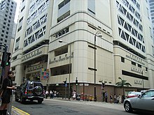
Sheung Wan Civic Centre, at the corner of Queen's Road Central and Morrison Street
|
|||||||||||
| Traditional Chinese | 上環 | ||||||||||
|---|---|---|---|---|---|---|---|---|---|---|---|
| Simplified Chinese | 上环 | ||||||||||
|
|||||||||||
| Transcriptions | |
|---|---|
| Standard Mandarin | |
| Hanyu Pinyin | Shànghuán |
| Yue: Cantonese | |
| Jyutping | Soeng6 waan4 |
Sheung Wan is an area in Hong Kong, located in the north-west of Hong Kong Island, between Central and Sai Ying Pun. Administratively, it is part of the Central and Western District. The name can be variously interpreted as Upper District (occupying relatively high ground compared to Central and Wan Chai), or Gateway District (perhaps a reference to the location where the British first entered and occupied Hong Kong).
Sheung Wan was one of the earliest settled places by the British, and belonged to the historical Victoria City. The site of the original occupation of Hong Kong Island by British forces in 1842 was at Possession Street, between Queen's Road Central and Hollywood Road. A plaque to this effect can be found in Hollywood Road Park at the top of Possession Street. The foot of Possession Street, Possession Point, was at that time on the shoreline, but is now several hundred yards inland due to reclamation.
Sheung Wan is surrounded by Sai Ying Pun in the west, Central in the east, Victoria Harbour in the north and Mid-Levels in the south. The border of Central and Sheung Wan is along Aberdeen Street and Wing Kut Street.
The Sheung Wan Route is one part of Central and Western Heritage Trail designed by the Antiquities and Monuments Office and Leisure and Cultural Services Department. The route covers 35 historic buildings and sites in Sheung Wan.
...
Wikipedia
