Clay County, Kentucky
| Clay County, Kentucky | |
|---|---|

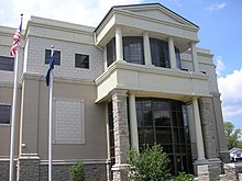
Clay County courthouse in Manchester
|
|
 Location in the U.S. state of Kentucky |
|
 Kentucky's location in the U.S. |
|
| Founded | 1807 |
| Named for | Green Clay |
| Seat | Manchester |
| Largest city | Manchester |
| Area | |
| • Total | 471 sq mi (1,220 km2) |
| • Land | 469 sq mi (1,215 km2) |
| • Water | 1.8 sq mi (5 km2), 0.4% |
| Population | |
| • (2010) | 21,730 |
| • Density | 46/sq mi (18/km²) |
| Congressional district | 5th |
| Time zone | Eastern: UTC-5/-4 |
| Website | claycounty |
Clay County is a county located in the U.S. state of Kentucky. As of the 2010 census, the population was 21,730. Its county seat is Manchester. The county was formed in 1807 and named in honor of Green Clay (1757–1826). Clay was a member of the Virginia and Kentucky State legislatures, first cousin once removed of Henry Clay, U.S. Senator from Kentucky and Secretary of State in the 19th century.
Clay County was established in 1807 from land given by Floyd, Knox and Madison counties. The courthouse burned in January 1936.
According to the U.S. Census Bureau, the county has a total area of 471 square miles (1,220 km2), of which 469 square miles (1,210 km2) is land and 1.8 square miles (4.7 km2) (0.4%) is water.
As of the census of 2010, there were 21,730 people, 8,556 households, and 6,442 families residing in the county. The population density was 52 people per square mile (20/km²). There were 9,439 housing units at an average density of 20 per square mile (8/km²). The racial makeup of the county was 93.92% White, 4.80% Black or African American, 0.21% Native American, 0.12% Asian, 0.02% Pacific Islander, 0.23% from other races, and 0.71% from two or more races. 1.36% of the population were Hispanics or Latinos of any race.
...
Wikipedia
