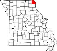
Clark County, Missouri
| Clark County, Missouri | |
|---|---|

Clark County Courthouse in Kahoka
|
|
 Location in the U.S. state of Missouri |
|
 Missouri's location in the U.S. |
|
| Founded | December 16, 1836 |
| Named for | William Clark |
| Seat | Kahoka |
| Largest city | Kahoka |
| Area | |
| • Total | 512 sq mi (1,326 km2) |
| • Land | 505 sq mi (1,308 km2) |
| • Water | 7.1 sq mi (18 km2), 1.4% |
| Population (est.) | |
| • (2015) | 6,801 |
| • Density | 14/sq mi (5/km²) |
| Congressional district | 6th |
| Time zone | Central: UTC-6/-5 |
| Clark County, Missouri | ||||
|---|---|---|---|---|
| Elected countywide officials | ||||
| Assessor | Donna F. Oilar | Democratic | ||
| Circuit Clerk | Mary D. Jones | Democratic | ||
| County Clerk | Leih Ann Hayden | Republican | ||
| Collector | Michelle Allen | Republican | ||
|
Commissioner (Presiding) |
Ron Brewer | Republican | ||
|
Commissioner (District 1) |
Jerry Neyens | Democratic | ||
|
Commissioner (District 2) |
Roger Sedore | Democratic | ||
| Coroner | Edwin Wilson | Republican | ||
| Prosecuting Attorney | John Moon | Democratic | ||
| Public Administrator | Linda Shoup | Republican | ||
| Recorder | Mary D. Jones | Democratic | ||
| Sheriff | Paul Gaudette | Republican | ||
| Surveyor | Patrick Poepping | Republican | ||
| Treasurer | Roberta McAfee | Republican | ||
| Clark County, Missouri | ||
|---|---|---|
| 2008 Republican primary in Missouri | ||
| John McCain | 195 (30.37%) | |
| Mike Huckabee | 283 (44.08%) | |
| Mitt Romney | 121 (18.85%) | |
| Ron Paul | 28 (4.36%) | |
| Clark County, Missouri | ||
|---|---|---|
| 2008 Democratic primary in Missouri | ||
| Hillary Clinton | 554 (63.90%) | |
| Barack Obama | 264 (30.45%) | |
| John Edwards (withdrawn) | 35 (4.04%) | |
| Uncommitted | 8 (0.92%) | |
Clark County is a county located in the U.S. state of Missouri. As of the 2010 census, the county's population was 7,139. Its county seat is Kahoka. The county was organized December 16, 1836 and named for William Clark, leader of the Lewis and Clark Expedition and later Governor of Missouri Territory.
Clark County is part of the Fort Madison–Keokuk, IA-IL-MO Micropolitan Statistical Area.
Missouri folklorist Margot Ford McMillen wrote that early settlers were attracted by Clark County's good and inexpensive agricultural land. One section was called "Bit Nation" because land was sold there for just twelve and one-half cents ("one bit" of a Spanish dollar) an acre.
According to the U.S. Census Bureau, the county has a total area of 512 square miles (1,330 km2), of which 505 square miles (1,310 km2) is land and 7.1 square miles (18 km2) (1.4%) is water.
As of the census of 2010, there were 7,139 people, 2,966 households, and 2,079 families residing in the county. The population density was 15 people per square mile (6/km²). There were 3,483 housing units at an average density of 7 per square mile (3/km²). The racial makeup of the county was 98.83% White, 0.07% Black or African American, 0.20% Native American, 0.07% Asian, 0.01% Pacific Islander, 0.22% from other races, and 0.61% from two or more races. Approximately 0.70% of the population were Hispanic or Latino of any race.
...
Wikipedia
