Clam Gulch
| Clam Gulch, Alaska | |
|---|---|
| CDP | |

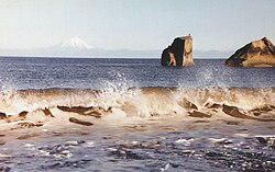
Waves on the rocky beach at Clam Gulch
|
|
 Location of Clam Gulch, Alaska |
|
| Coordinates: 60°13′40″N 151°23′38″W / 60.22778°N 151.39389°W | |
| Country | United States |
| State | Alaska |
| Borough | Kenai Peninsula |
| Government | |
| • Borough mayor | Mike Navarre |
| • State senator | Gary Stevens (R) |
| • State rep. | Paul Seaton (R) |
| Area | |
| • Total | 13.7 sq mi (35.6 km2) |
| • Land | 13.7 sq mi (35.6 km2) |
| • Water | 0 sq mi (0 km2) |
| Elevation | 269 ft (82 m) |
| Population (2010) | |
| • Total | 176 |
| Time zone | Alaska (AKST) (UTC-9) |
| • Summer (DST) | AKDT (UTC-8) |
| ZIP code | 99568 |
| Area code(s) | 907 |
| FIPS code | 02-15320 |
| GNIS feature ID | 1412797 |
Clam Gulch is a census-designated place (CDP) in Kenai Peninsula Borough, Alaska, United States. At the 2010 census the population was 176, up from 173.
Clam Gulch is located at 60°13′40″N 151°23′38″W / 60.22778°N 151.39389°W (60.227786, -151.393907) on the shores of Cook Inlet. The only road access is via the Sterling Highway.
According to the United States Census Bureau, the CDP has a total area of 13.7 square miles (35 km2), all of it land.
//www.google.com/maps/@60.2258704,-151.402415,1626m/data=!3m1!1e3
Clam Gulch first appeared as an unincorporated village on the 1970 U.S. Census. It was made a census-designated place (CDP) in 1980.
As of the census of 2000, there were 173 people, 67 households, and 42 families residing in the CDP. The population density was 12.6 people per square mile (4.9/km²). There were 115 housing units at an average density of 8.4/sq mi (3.2/km²). The racial makeup of the CDP was 92.49% White, 2.89% Native American, 1.16% Asian, and 3.47% from two or more races.
...
Wikipedia
