Ciudad del Carmen, Campeche
| Ciudad del Carmen | ||
|---|---|---|
| City | ||

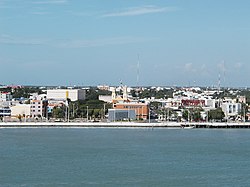
View of the city from the Terminos Lagoon
|
||
|
||
| Coordinates: 18°38′N 91°50′W / 18.633°N 91.833°WCoordinates: 18°38′N 91°50′W / 18.633°N 91.833°W | ||
| Country |
|
|
| State |
|
|
| Municipality | Carmen | |
| City Founded | July 16, 1717 | |
| Government | ||
| • Mayor | Pablo Gutierrez Lazarus (PAN) | |
| Elevation | 2 m (6,6 ft) | |
| Population (INEGI2010) | ||
| • Total | 169,466 | |
| • Demonym | Carmelita | |
| Time zone | CST (UTC−6) | |
| • Summer (DST) | CDT (UTC−5) | |
| Area code(s) | 938 | |
| Major Airport | Ciudad del Carmen International Airport | |
| IATA Code | CME | |
| ICAO Code | MMCE | |
| Website | http://www.carmen.gob.mx/ | |
Ciudad del Carmen is a city in the southwest of the Mexican state of Campeche. Ciudad del Carmen is located at 18°38′N 91°50′W / 18.63°N 91.83°W on the southwest of Carmen Island, which stands in the Laguna de Términos on the coast of the Gulf of Mexico. As of 2010[update], Ciudad del Carmen had a population of 169,466, up from the 2005 census of 154,197. In July 2006 Ciudad del Carmen celebrated its 150th anniversary as a city.
The city is nicknamed "The Pearl of the Gulf". Ciudad del Carmen was a small city mostly devoted to fishing until the 1970s when oil was discovered in the region; since then it has grown and developed substantially. To this day Carmen is known as one of the best locations to find seafood in Mexico. As late as the early 1980s the city could long be reached only by ferry boats called "pangas" or small motorboats ("lanchas") operating between Ciudad del Carmen and Zacatal; this changed with the construction of a causeway bridge to the mainland in the 1980s (eastbound) and another one in 1994 (westbound). The construction of the first bridge was motivated by the sinking of one of the island's pangas which resulted in the death of nearly everyone on board. The bridge Puente El Zacatal, constructed in 1994, is one of the longest in Latin America.
This border area at the western edge of the Yucatán Peninsula was previously part of the state of Yucatán, then of Tabasco; since 1863 it has been part of the state of Campeche. In 1840 the city had a population of about 7,000.
...
Wikipedia


