City of Hood River
| Hood River, Oregon | ||
|---|---|---|
| City | ||

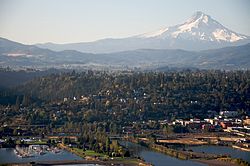
Aerial photo of the city of Hood River
|
||
|
||
| Nickname(s): Windsurfing Capital of the World | ||
 Location in Oregon |
||
| Location in the United States | ||
| Coordinates: 45°42′24″N 121°31′18″W / 45.70667°N 121.52167°WCoordinates: 45°42′24″N 121°31′18″W / 45.70667°N 121.52167°W | ||
| Country | United States | |
| State | Oregon | |
| County | Hood River | |
| Incorporated | 1895 | |
| Government | ||
| • Mayor | Paul Blackburn | |
| Area | ||
| • Total | 3.35 sq mi (8.68 km2) | |
| • Land | 2.55 sq mi (6.60 km2) | |
| • Water | 0.80 sq mi (2.07 km2) | |
| Elevation | 160 ft (50 m) | |
| Population (2010) | ||
| • Total | 7,167 | |
| • Estimate (2012) | 7,292 | |
| • Density | 2,810.6/sq mi (1,085.2/km2) | |
| Time zone | Pacific (UTC-8) | |
| • Summer (DST) | Pacific (UTC-7) | |
| ZIP code | 97031 | |
| Area code(s) | 458 and 541 | |
| FIPS code | 41-34900 | |
| GNIS feature ID | 1136388 | |
| Website | www.ci.hood-river.or.us | |
The city of Hood River is the seat of Hood River County, Oregon, United States. It is a port on the Columbia River, and is named for the nearby Hood River. As of the 2010 census, the city population was 7,167.
Hood River (originally called Dog River) post office was established (named by Mary Coe) at the site of the present city on September 30, 1858, and the city itself was incorporated in 1895. Originally, the city was part of Wasco County, but it became the seat of Hood River County when the county was first established in 1908.
Hood River is at the confluence of the Hood River and the Columbia River in the heart of the Columbia River Gorge. The city is about 30 miles (48 km) north of Mount Hood, the tallest peak in the state. It is across the Columbia River from White Salmon, Washington. South of the city is the Hood River Valley, known for its production of apples, pears, and cherries.
According to the United States Census Bureau, the city has a total area of 3.35 square miles (8.68 km2), of which, 2.55 square miles (6.60 km2) is land and 0.80 square miles (2.07 km2) is water.
Located at the transition zone between wet temperate rainforest to the west, and dry shrub-steppe desert to the east, Hood River has a moderate climate with rainy winters and warm summers, although rainfall there is somewhat less than Portland and other nearby areas in the Willamette Valley. Hood River averages around 30 inches (760 mm) of precipitation a year, while Cascade Locks, 20 miles (32 km) west, receives over 75 inches (1,900 mm), and The Dalles, 20 miles (32 km) east, less than 15 inches (380 mm). The area is known for its consistently high winds channeling down the Columbia River Gorge.
...
Wikipedia


