Chudovsky District
| Chudovsky District Чудовский район (Russian) |
|
|---|---|
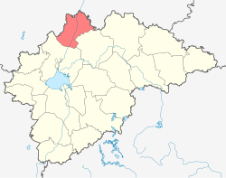
 Location of Chudovsky District in Novgorod Oblast |
|
| Coordinates: 59°08′N 31°40′E / 59.133°N 31.667°ECoordinates: 59°08′N 31°40′E / 59.133°N 31.667°E | |
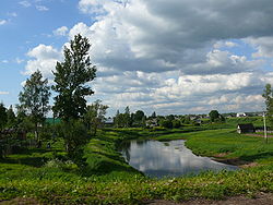
 The Kerest River in the town of Chudovo, Chudovsky District |
|
|
|
|
| Location | |
| Country | Russia |
| Federal subject | Novgorod Oblast |
| Administrative structure (as of April 2012) | |
| Administrative center | town of Chudovo |
| Administrative divisions: | |
| Towns of district significance | 1 |
| Settlements | 3 |
| Inhabited localities: | |
| Cities/towns | 1 |
| Rural localities | 83 |
| Municipal structure (as of January 2012) | |
| Municipally incorporated as | Chudovsky Municipal District |
| Municipal divisions: | |
| Urban settlements | 1 |
| Rural settlements | 3 |
| Statistics | |
| Area (municipal district) | 2,370 km2 (920 sq mi) |
| Population (2010 Census) | 22,011 inhabitants |
| • Urban | 70.0% |
| • Rural | 30.0% |
| Density | 9.29/km2 (24.1/sq mi) |
| Time zone | MSK (UTC+03:00) |
| Established | October 1, 1927 |
| Official website | |
| on | |
Chudovsky District (Russian: Чу́довский райо́н) is an administrative and municipal district (raion), one of the twenty-one in Novgorod Oblast, Russia. It is located in the north of the oblast and borders with Kirishsky District of Leningrad Oblast in the northeast, Malovishersky District in the southeast, Novgorodsky District in the southwest, and with Tosnensky District of Leningrad Oblast in the northwest. The area of the district is 2,370 square kilometers (920 sq mi). Its administrative center is the town of Chudovo. Population: 22,011 (2010 Census); 25,829 (2002 Census);27,355 (1989 Census). The population of Chudovo accounts for 70.0% of the district's total population.
The district is located in the Ilmen Lowlands and is crossed by the Volkhov River from southwest to northeast, dividing the district into approximately equal areas. The highest point in the district is 63 meters (207 ft) above sea level. All rivers in the district drain into the Volkhov and its main tributaries, including the Oskuya (right), the Pchyozhva (right), the Kerest (left), and the Tigoda (left).
...
Wikipedia


