Christopher Park
| Stonewall National Monument | |
|---|---|

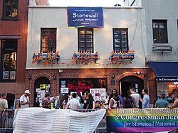
Stonewall Inn the day after President Obama's dedication in June 2016
|
|
| Type | Cultural |
| Location | West Village, Manhattan, New York City |
| Coordinates | 40°44′1.939″N 74°0′7.83″W / 40.73387194°N 74.0021750°WCoordinates: 40°44′1.939″N 74°0′7.83″W / 40.73387194°N 74.0021750°W |
| Area | 7.7 acres (3.1 ha) near the intersection of Christopher Street and 7th Avenue |
| Built |
|
| Governing body | Private |
| Designated | June 28, 1999 |
| Designated | February 16, 2000 |
| Designated | June 24, 2016 |
Stonewall National Monument is a 7.7-acre (3.1 ha) U.S. National Monument located in the West Village neighborhood of Greenwich Village in Lower Manhattan, New York City. The designated area includes Christopher Park and the block of Christopher Street bordering the park, which is directly across the street from the Stonewall Inn—the site of the Stonewall riots of June 28, 1969, widely regarded as the start of the modern LGBT rights movement in the United States.
Stonewall National Monument is the first U.S. National Monument dedicated to LGBT rights and history. It received its National Monument designation on June 24, 2016.
Stonewall National Monument encompasses the 0.19-acre (0.077 ha)Christopher Park (also known as Christopher Street Park), a park originally built on a lot that New Netherland Director-General Wouter van Twiller settled as a tobacco farm from 1633 to 1638, when he died. The land was subsequently split up into 3 different farms. Trinity Church's and Elbert Herring's farms were located in the southern part of van Twiller's former farm, and Sir Peter Warren’s farm was located in the northern portion.
Because of the unusual street grid that already existed in much of Greenwich Village, the Commissioners' Plan of 1811 would not quite fit into the pre-existing street grid. This resulted in several blocks with oblique angles, as well as many triangular street blocks. The former farms of Christopher Street were split into small lots from 1789 to 1829. After a subsequent large population increase in the early 19th century, the buildings on Christopher Street were dense with people. In 1835, the Great Fire of New York spread through the area and destroyed many city blocks. The little triangle of land bounded by Christopher, Grove, and 4th Streets, which was burned down, was condemned and turned into a park. The new Christopher Street Park, designed by architects Calvert Vaux and Samuel Parsons, Jr., was opened in 1837. The Stonewall Inn, which then consisted simply of two adjacent stables, opened across Christopher Street in 1843.
...
Wikipedia


