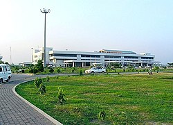
Chittagong International Airport
|
Shah Amanat International Airport শাহ আমানত আন্তর্জাতিক বিমানবন্দর |
|||||||||||
|---|---|---|---|---|---|---|---|---|---|---|---|
 |
|||||||||||
| Summary | |||||||||||
| Airport type | Public, military | ||||||||||
| Owner | Bangladesh government | ||||||||||
| Operator | Civil Aviation Authority of Bangladesh | ||||||||||
| Serves | Chittagong, Bangladesh | ||||||||||
| Location | Patenga | ||||||||||
| Hub for | |||||||||||
| Elevation AMSL | 12 ft / 4 m | ||||||||||
| Coordinates | 22°14′59″N 91°48′48″E / 22.24972°N 91.81333°ECoordinates: 22°14′59″N 91°48′48″E / 22.24972°N 91.81333°E | ||||||||||
| Website | chittagongairport |
||||||||||
| Map | |||||||||||
| Location of airport in Bangladesh | |||||||||||
| Runways | |||||||||||
|
|||||||||||
|
Source: Civil Aviation Authority of Bangladesh
|
|||||||||||
Shah Amanat International Airport (IATA: CGP, ICAO: VGEG) (Bengali: শাহ আমানত আন্তর্জাতিক বিমানবন্দর Shah Amanôt Antôrjatik Bimanbôndôr) is an international airport serving Bangladesh's southeastern port city of Chittagong. Operated and maintained by the Civil Aviation Authority of Bangladesh, it is the second-largest international airport in Bangladesh After Dhaka International Airport Hazrat Shahjalal Airport of Bangladesh. It is also used by the Bangladesh Air Force as a part of BAF Zahurul Haq Base. It was formerly known as MA Hannan International Airport, named after Awami League politician M. A. Hannan, but was renamed on 2 April 2005 by the Government of Bangladesh, after an Islamic saint, Hazrat Shah Amanat.
The airport is capable of annually handling 1.5 million passengers and 6,000 tonnes of cargo. The airport is served by nine passenger airlines which connect the airport internationally with a few Middle Eastern cities, Bangkok, Kolkata and Kuala Lumpur, along with domestic flights to Dhaka. Emirates SkyCargo and Etihad Cargo offer freighter flights to Dubai, Abu Dhabi, Hong Kong and Guangzhou.
...
Wikipedia

