Chester, South Carolina
| Chester, South Carolina | |
|---|---|
| City | |

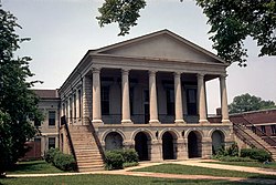
Chester County Courthouse, built in 1852
|
|
| Nickname(s): The Picture Perfect City; The Little City on the Big Hill | |
 Location of Chester, South Carolina |
|
| Coordinates: 34°42′20″N 81°12′42″W / 34.70556°N 81.21167°WCoordinates: 34°42′20″N 81°12′42″W / 34.70556°N 81.21167°W | |
| Country | United States |
| State | South Carolina |
| County | Chester |
| Government | |
| • Type | Council |
| • Mayor | George Caldwell |
| Area | |
| • Total | 3.27 sq mi (8.46 km2) |
| • Land | 3.27 sq mi (8.46 km2) |
| • Water | 0.0 sq mi (0.0 km2) |
| Elevation | 535 ft (163 m) |
| Population (2010) | |
| • Total | 5,607 |
| • Density | 1,716/sq mi (662.6/km2) |
| Time zone | Eastern (EST) (UTC-5) |
| • Summer (DST) | EDT (UTC-4) |
| ZIP code | 29706 |
| Area code(s) | 803 |
| FIPS code | 45-14095 |
| GNIS feature ID | 1247275 |
| Website | www |
Chester is a small rural city in Chester County, South Carolina, United States. The population was 5,607 at the 2010 census, down from 6,476 at the 2000 census. It is the county seat of Chester County.
The Catholic Presbyterian Church, Chester City Hall and Opera House, Chester Historic District, Colvin-Fant-Durham Farm Complex, Fishdam Ford, Kumler Hall, Lewis Inn, and McCollum Mound are listed on the National Register of Historic Places.
Chester is located just west of the center of Chester County at 34°42′20″N 81°12′42″W / 34.70556°N 81.21167°W (34.705553, -81.211638).U.S. Route 321 bypasses the city to the west and the south, leading north 22 miles (35 km) to York and south 25 miles (40 km) to Winnsboro. South Carolina Highway 9 passes through the city center and leads east 11 miles (18 km) to Interstate 77 near Richburg and west 49 miles (79 km) to Spartanburg. Highways 72 and 121 lead northeast 19 miles (31 km) to Rock Hill and southwest 28 miles (45 km) to Whitmire.
...
Wikipedia
