Chester, Georgia
| Chester, Georgia | |
|---|---|
| Town | |
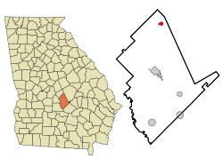
 Location in Dodge County and the state of Georgia |
|
| Coordinates: 32°23′42″N 83°9′13″W / 32.39500°N 83.15361°WCoordinates: 32°23′42″N 83°9′13″W / 32.39500°N 83.15361°W | |
| Country | United States |
| State | Georgia |
| County | Dodge |
| Incorporated (town) | 1912 |
| Area | |
| • Total | 0.9 sq mi (2.3 km2) |
| • Land | 0.9 sq mi (2.3 km2) |
| • Water | 0 sq mi (0 km2) |
| Elevation | 367 ft (112 m) |
| Population (2010) | |
| • Total | 1,596 |
| • Density | 1,832/sq mi (707.4/km2) |
| Time zone | Eastern (EST) (UTC-5) |
| • Summer (DST) | EDT (UTC-4) |
| ZIP code | 31012 |
| Area code(s) | 478 |
| FIPS code | 13-15900 |
| GNIS feature ID | 0331384 |
Chester is a town in Dodge County, Georgia, United States. The population was 1,596 at the 2010 census, up from 305 at the 2000 census due to inclusion of Dodge State Prison within the town limits.
Chester is located in northern Dodge County at 32°23′42″N 83°9′13″W / 32.39500°N 83.15361°W (32.394965, -83.153610).Georgia State Route 126 passes through the town as Main Street, leading west 13 miles (21 km) to Cochran and southeast 8 miles (13 km) to Cadwell. Georgia State Route 257 joins SR 126 on Main Street through the center of Chester, but leads northeast 7 miles (11 km) to Dexter and southwest 9 miles (14 km) to Empire. Eastman, the Dodge County seat, is 15 miles (24 km) to the south via Chester Highway.
According to the United States Census Bureau, Chester has a total area of 0.89 square miles (2.3 km2), all of it land.
As of the census of 2000, there were 305 people, 133 households, and 82 families residing in the town. The population density was 349.0 people per square mile (135.4/km²). There were 167 housing units at an average density of 191.1 per square mile (74.1/km²). The racial makeup of the town was 54.10% White, 44.59% African American, 0.66% from other races, and 0.66% from two or more races.
...
Wikipedia
