Dexter, Georgia
| Dexter, Georgia | |
|---|---|
| Town | |
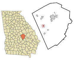
 Location in Laurens County and the state of Georgia |
|
| Coordinates: 32°26′4″N 83°3′32″W / 32.43444°N 83.05889°WCoordinates: 32°26′4″N 83°3′32″W / 32.43444°N 83.05889°W | |
| Country | United States |
| State | Georgia |
| County | Laurens |
| Area | |
| • Total | 0.8 sq mi (2 km2) |
| • Land | 0.8 sq mi (2 km2) |
| • Water | 0 sq mi (0 km2) |
| Elevation | 312 ft (95 m) |
| Population (2000) | |
| • Total | 509 |
| • Density | 636.3/sq mi (254.5/km2) |
| Time zone | Eastern (EST) (UTC-5) |
| • Summer (DST) | EDT (UTC-4) |
| ZIP code | 31019 |
| Area code(s) | 478 |
| FIPS code | 13-22752 |
| GNIS feature ID | 0331543 |
Dexter is a town in Laurens County, Georgia, United States. The population was 509 at the 2000 census. It is part of the Dublin Micropolitan Statistical Area.
Dexter is located at 32°26′4″N 83°3′32″W / 32.43444°N 83.05889°W (32.434580, -83.058904).
According to the United States Census Bureau, the town has a total area of 0.8 square miles (2.1 km2), of which, 0.8 square miles (2.1 km2) of it is land and 0.04 square miles (0.10 km2) of it (2.60%) is water.
As of the census of 2000, there were 509 people, 207 households, and 143 families residing in the town. The population density was 670.4 people per square mile (258.6/km²). There were 231 housing units at an average density of 304.2 per square mile (117.4/km²). The racial makeup of the town was 77.41% White and 22.59% African American. Hispanic or Latino of any race were 0.20% of the population.
There were 207 households out of which 31.4% had children under the age of 21 living with them, 58.0% were married couples living together, 9.7% had a female householder with no husband present, and 30.9% were non-families. 29.0% of all households were made up of individuals and 21.3% had someone living alone who was 65 years of age or older. The average household size was 2.46 and the average family size was 3.05.
...
Wikipedia
