Chandra Tal
| Chandra Taal | |
|---|---|
 |
|
| Location | Middle Himalaya, Spiti Valley, Himachal Pradesh, |
| Coordinates | 32°28′31″N 77°37′01″E / 32.47518°N 77.61706°ECoordinates: 32°28′31″N 77°37′01″E / 32.47518°N 77.61706°E |
| Type | Sweet Water Lake |
| Basin countries | India |
| Max. length | 1 km (0.62 mi) |
| Max. width | 0.5 km (0.31 mi) |
| Surface elevation | 4,250 m (13,940 ft) |
| Islands | 1 |
| Official name | Chandertal Wetland |
| Designated | 8 November 2005 |
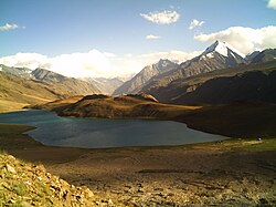
Chandra Taal (meaning the Lake of the Moon), or Chandra Tal is situated in the Spiti part of the Lahul and Spiti district of Himachal Pradesh (India). The name of the lake originates from its crescent shape. It is situated at an altitude of about 4,300 metres (14,100 ft) in the Himalayas. Mountains of scree overlook the lake on one side, and a magnificent cirque presents a view on the other. Chandra Taal is a popular destination for trekkers and campers. The lake is accessible on foot from Batal as well as from Kunzum Pass from late May to early October. There is also a motorable road from Batal which is 14 km (8.7 mi) away from Chandra Taal. The road from Kunzum Pass is accessible only on foot, and it is about 8 km (5.0 mi) from Chandra Taal. Suraj Tal is also accessible Chandra Taal, 30 km (19 mi) away. Vast meadows on the banks of the lake are the camping sites. During springtime, these meadows are carpeted with hundreds of kinds of wildflowers.
The lake is situated on the Samudra Tapu plateau, which overlooks the Chandra River.
The lake is one of two high-altitude wetlands of India which have been designated as Ramsar sites.
Chandra Taal offers magnificent view at night (after sunset). While temperature drops below Zero degree celsius during pre-winter, the sky is filled count-less stars & offers Spectacular Milky way view.
...
Wikipedia

