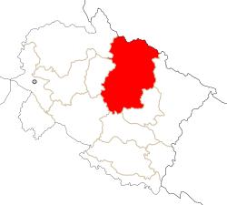
Chamoli District
|
Chamoli district चमोली ज़िला |
|
|---|---|
| District | |
 Location in Uttarakhand |
|
| Coordinates: 30°25′N 79°20′E / 30.42°N 79.33°ECoordinates: 30°25′N 79°20′E / 30.42°N 79.33°E | |
| Country | India |
| State | Uttarakhand |
| Division | Garhwal |
| Headquarters | Chamoli Gopeshwar |
| Area855 km2claimed by | |
| • Total | 8,030 km2 (3,100 sq mi) |
| Population | |
| • Total | 370,359 |
| • Density | 49/km2 (130/sq mi) |
| Languages | |
| • Official | Hindi, Garhwali |
| Time zone | IST (UTC+5:30) |
| Vehicle registration | UK |
| Website | chamoli |
Chamoli district is the second largest district of Uttarakhand state of India. It is bounded by the Tibet region to the north, and by the Uttarakhand districts of Pithoragarh and Bageshwar to the east, Almora to the south, Garhwal to the southwest, Rudraprayag to the west, and Uttarkashi to the northwest. The administrative headquarters of the district is Gopeshwar.
Chamoli hosts a variety of destinations of pilgrim and tourists' interest. Badrinath, Hemkund Sahib, Valley of Flowers and Auli. Chamoli also happened to be a birthplace of "Chipko movement". Chamoli proved itself "the most spectacular in its natural assets; be it scenery, valley aspects, water-edges, floristic varieties, dramatic landform or the climatic cardinalities". The district is also inhabited by Bhotiya ethnic group who adhere to Hinduism.
The region covered by the district of Chamoli forms part of the Pauri Garhwal district of the Kumaon till 1960. It occupies the northeastern corner of the Garhwal tract and lies in the central or mid-Himalayas in the very heart of the snowy range described in ancient books as Bahirgiri, one of the three divisions of the Himalayan mountains.
Chamoli, the district of “Garhwal’’ the land of forts. Today’s Garhwal was known as kedar-khand in the past. In puranas kedar-khand was said to be abode of God. It seems from the facts vedas puranas, Ramayna and Mahabharat that these Hindu scriptures are scripted in kedar-khand. It is believed that God Ganesha first script of vedas in Vayas gufa situated in the last village Mana only four km. from Badrinath.
...
Wikipedia
