Chagos islands
| Disputed islands | |
|---|---|

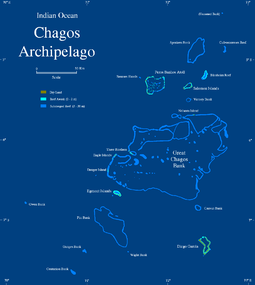
Map of the Chagos Archipelago
|
|
| Geography | |
| Location | Indian Ocean |
| Coordinates | 6°00′S 71°30′E / 6.000°S 71.500°ECoordinates: 6°00′S 71°30′E / 6.000°S 71.500°E |
| Major islands | Diego Garcia, Peros Banhos, Salomon Islands, Egmont Islands |
| Area | 56.13 km2 |
| Administered by | |
| British Indian Ocean Territory (UK) | |
| Capital and largest settlement | Eclipse Point Town (3,000) |
| Claimed by | |
| Mauritius | |
| Outer islands | Chagos Archipelago |
| Seychelles | |
| Demographics | |
| Population | 3,000 (as of 2014) |
| Ethnic groups | |
The Chagos Archipelago (/ˈtʃɑːɡoʊs/ or /ˈtʃɑːɡəs/) or Chagos Islands (formerly the Bassas de Chagas, and later the Oil Islands) is a group of seven atolls comprising more than 60 individual tropical islands in the Indian Ocean about 500 kilometres (310 mi) south of the Maldives archipelago. This chain of islands is the southernmost archipelago of the Chagos-Laccadive Ridge, a long submarine mountain range in the Indian Ocean.
Officially part of the British Indian Ocean Territory, the Chagos were home to the Chagossians, a Bourbonnais Creole speaking people, for more than a century and a half until the United Kingdom evicted them between 1967 and 1973 to allow the United States to build a military base on Diego Garcia, the largest of the Chagos Islands. Since 1971, only the atoll of Diego Garcia is inhabited, and only by military and civilian contracted personnel.
The sovereignty of the Chagos Archipelago is being disputed between the UK and Mauritius. The United Kingdom excised the archipelago from Mauritian territory prior to Mauritius' independence.
...
Wikipedia

