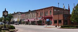
Chadron, NE
| Chadron, Nebraska | |
|---|---|
| City | |

The Chadron Commercial Historic District is listed in the National Register of Historic Places.
|
|
 Location of Chadron within Dawes County and Nebraska |
|
 Detailed map of Chadron |
|
| Coordinates: 42°49′39″N 103°0′11″W / 42.82750°N 103.00306°WCoordinates: 42°49′39″N 103°0′11″W / 42.82750°N 103.00306°W | |
| Country | United States |
| State | Nebraska |
| County | Dawes |
| Area | |
| • Total | 3.85 sq mi (9.97 km2) |
| • Land | 3.85 sq mi (9.97 km2) |
| • Water | 0 sq mi (0 km2) |
| Elevation | 3,379 ft (1,030 m) |
| Population (2010) | |
| • Total | 5,851 |
| • Estimate (2012) | 5,844 |
| • Density | 1,519.7/sq mi (586.8/km2) |
| Time zone | Mountain (MST) (UTC-7) |
| • Summer (DST) | MDT (UTC-6) |
| ZIP code | 69337 |
| Area code(s) | 308 |
| FIPS code | 31-08605 |
| GNIS feature ID | 0835519 |
| Website | chadron-nebraska.com |
Chadron (/ˈʃædrən/ SHAD-rən) is a city in Dawes County, in the state of Nebraska in the Great Plains region of the United States. The population was 5,851 at the 2010 census. It is the county seat of Dawes County, and the location of Chadron State College.
Chadron also is the United States Forest Service headquarters of the Nebraska and Samuel R. McKelvie National Forests, and the Buffalo Gap, Fort Pierre, and Oglala National Grasslands. The Museum of the Fur Trade is located near Chadron, at the site of the American Fur Company's former Bordeaux Trading Post.
Succeeding cultures of indigenous peoples lived in the area for thousands of years. In historic times, tribes such as the Oglala Lakota (Oglala Sioux Tribe), Cheyenne and others lived in the area. The Sioux used this territory as a hunting ground after pushing other tribes to the west.
...
Wikipedia
