Château-Gontier
| Château-Gontier | ||
|---|---|---|

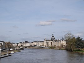
Château-Gontier seen from the Europe Bridge
|
||
|
||
| Coordinates: 47°49′43″N 0°42′10″W / 47.8286°N 0.7028°WCoordinates: 47°49′43″N 0°42′10″W / 47.8286°N 0.7028°W | ||
| Country | France | |
| Region | Pays de la Loire | |
| Department | Mayenne | |
| Arrondissement | Château-Gontier | |
| Canton | 2 cantons | |
| Government | ||
| • Mayor (2014–2020) | Philippe Henry | |
| Area1 | 27.88 km2 (10.76 sq mi) | |
| Population (2006)2 | 11,025 | |
| • Density | 400/km2 (1,000/sq mi) | |
| Time zone | CET (UTC+1) | |
| • Summer (DST) | CEST (UTC+2) | |
| INSEE/Postal code | 53062 /53200 | |
| Elevation | 26–99 m (85–325 ft) (avg. 83 m or 272 ft) |
|
|
1 French Land Register data, which excludes lakes, ponds, glaciers > 1 km² (0.386 sq mi or 247 acres) and river estuaries. 2Population without double counting: residents of multiple communes (e.g., students and military personnel) only counted once. |
||
1 French Land Register data, which excludes lakes, ponds, glaciers > 1 km² (0.386 sq mi or 247 acres) and river estuaries.
Château-Gontier (French pronunciation: [ʃɑto ɡɔ̃tje]) is a commune in the Mayenne department in north-western France.
It is about 30 km (19 mi) south of Laval, the préfecture of the department of Mayenne. Château-Gontier is home to the Refuge de l'Arche[1], a refuge for abandoned or mistreated animals.
There are chalybeate springs close to the town. Château-Gontier owes its origin and its name to a castle erected in the first half of the 11th century by Gunther, the steward of Fulk Nerra of Anjou, on the site of a farm belonging to the monks of St Aubin d’Angers. On the extinction of the family, the lordship was assigned by Louis XI. to Philippe de Comines. The town suffered severely during the wars of the League. In 1793 it was occupied by the Vendeans.
...
Wikipedia


