Central and Western
|
Central and Western 中西區 |
||
|---|---|---|
| District | ||
| Central and Western District | ||

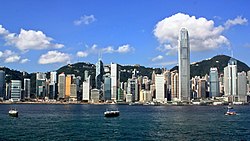
Day view of the Central and Western District skyline
|
||
|
||
 Location within Hong Kong |
||
| Coordinates: 22°17′12″N 114°09′18″E / 22.28666°N 114.15497°ECoordinates: 22°17′12″N 114°09′18″E / 22.28666°N 114.15497°E | ||
| Country | Hong Kong | |
| Division | Hong Kong Island | |
| Government | ||
| • District Officer | Eliza Yau | |
| • District Council Chairman | David Yip | |
| Area | ||
| • Total | 12.52 km2 (4.83 sq mi) | |
| • Land | 12.40 km2 (4.79 sq mi) | |
| • Water | .12 km2 (0.05 sq mi) 1% | |
| Population (2011) | ||
| • Total | 251,519 | |
| • Density | 20,000/km2 (52,000/sq mi) | |
| Time zone | Hong Kong Time (UTC+8) | |
| Website | Central and Western District | |
| Central and Western District | |||||||||||||||

|
|||||||||||||||
| Traditional Chinese | 中西區 | ||||||||||||||
|---|---|---|---|---|---|---|---|---|---|---|---|---|---|---|---|
| Simplified Chinese | 中西区 | ||||||||||||||
| Cantonese Yale | Jūngsāi Kēui | ||||||||||||||
| Literal meaning | Central Western District | ||||||||||||||
|
|||||||||||||||
| Transcriptions | |
|---|---|
| Standard Mandarin | |
| Hanyu Pinyin | Zhōngxī Qū |
| Yue: Cantonese | |
| Yale Romanization | Jūngsāi Kēui |
| IPA | [tsóŋ.sɐ́i̯ kʰɵ́y̯] |
| Jyutping | Zung1sai1 Keoi1 |
The Central and Western District (Chinese: 中西區; Cantonese Yale: Jūngsāi Kēui) located on northern part of Hong Kong Island is one of the 18 administrative districts of Hong Kong. It had a population of 251,519 in 2011. The district has the most educated residents with the second highest income and the third lowest population due to its relatively small size.
Central is the central business district and the core urban area of Hong Kong. Western District covers Shek Tong Tsui, Kennedy Town and Sai Ying Pun, and was part of the City of Victoria, the earliest urban settlement in colonial Hong Kong.
Central District, as Victoria City, was the first area of planned urban development in Hong Kong during the colonial era. The British held a land sale in June 1841, six months after the flag was raised at Possession Point. A total of 51 lots of land were sold to 23 merchant houses to build offices and warehouses. The property buyers included Dent's, Jardine's, Russell's and Olyphant's. At the time, the two roads Albany Nullah (now Garden Road) and Glenealy Nullah (now Glenealy) were mainly used by the British. The streets later became known as Government Hill.
...
Wikipedia

