Central, South Carolina
| Central, South Carolina | |
|---|---|
| Town | |

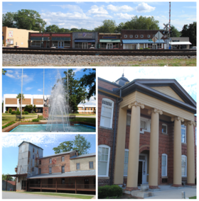
Top, left to right: Downtown Central, Southern Wesleyan University, Central Roller Mills, Central High School
|
|
 Location of Central within South Carolina |
|
| Coordinates: 34°43′26″N 82°46′47″W / 34.72389°N 82.77972°WCoordinates: 34°43′26″N 82°46′47″W / 34.72389°N 82.77972°W | |
| Country | United States |
| State | South Carolina |
| County | Pickens |
| Incorporated | 1875 |
| Government | |
| • Mayor | Mac Martin |
| Area | |
| • Total | 2.4 sq mi (6.2 km2) |
| • Land | 2.4 sq mi (6.2 km2) |
| • Water | 0.0 sq mi (0.0 km2) |
| Elevation | 912 ft (278 m) |
| Population (2010) | |
| • Total | 5,159 |
| • Density | 2,100/sq mi (830/km2) |
| Time zone | Eastern (EST) (UTC-5) |
| • Summer (DST) | EDT (UTC-4) |
| ZIP code | 29630 |
| Area code | 864 |
| FIPS code | 45-13015 |
| GNIS feature ID | 1247236 |
| Website | cityofcentral.org |
Central is a town in Pickens County, South Carolina, United States. As of the 2010 census, the population was 5,159, roughly 3000 of which were considered permanent residents. Contrary to its name, it is not near the center of South Carolina. It received its name from its geographic location, being the halfway or central point between Atlanta and Charlotte along the former Atlanta and Richmond Air-Line Railway line. The primary campus of Southern Wesleyan University is located east of the downtown area.
Central was founded by the Atlanta and Richmond Air Line Company in a railroad boon that began in 1873. The town's name represents the fact that it is midway between Atlanta and Charlotte. Central was incorporated as a town on March 17, 1875.
In 1897, Southern Railway moved its headquarters from Central to Greenville; trains no longer stopped to change engines, and soon all shops and offices were closed. The establishment of Issaqueena Mill and in 1906, Wesleyan Methodist Bible Institute (now Southern Wesleyan University) brought people back to the town.
Two buildings on Church Street in Central are listed on the National Register of Historic Places: Central High School and Morgan House. The Central Roller Mills on Madden Bridge Rd. was listed in 2013.
Central is located at 34°43′26″N 82°46′47″W / 34.723781°N 82.779754°W. According to the United States Census Bureau, the town has a total area of 2.4 square miles (6.2 km2), all of it land.
...
Wikipedia
