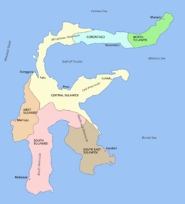
Celebes Island

Provincial Division
|
|
| Geography | |
|---|---|
| Location | South East Asia |
| Coordinates | 02°S 121°E / 2°S 121°ECoordinates: 02°S 121°E / 2°S 121°E |
| Archipelago | Greater Sunda Islands |
| Area | 180,680.7 km2 (69,761.2 sq mi) |
| Area rank | 11th |
| Highest elevation | 3,478 m (11,411 ft) |
| Highest point | Rantemario |
| Administration | |
|
Indonesia
|
|
| Provinces (capital) |
|
| Largest settlement | Makassar (pop. 1,338,633) |
| Demographics | |
| Population | 18,455,058 (2014 estimate) |
| Pop. density | 105.7 /km2 (273.8 /sq mi) |
| Ethnic groups | Makassarese, Buginese, Mandar, Minahasa, Gorontalo, Toraja, Butonese, Bajau, Mongondow |
Sulawesi, formerly known as Celebes (/ˈsɛlᵻbiːz/ or /sᵻˈliːbiːz/), is an island in Indonesia. One of the four Greater Sunda Islands, and the world's eleventh-largest island, it is situated between Borneo and the Maluku Islands. Within Indonesia, only Sumatra, Borneo and Papua are larger in territory, and only Java and Sumatra have larger populations.
Four peninsulas comprise Sulawesi: the northern Minahasa Peninsula; the East Peninsula; the South Peninsula; and the South-east Peninsula. Three gulfs separate these peninsulas: the Gulf of Tomini between northern Minahasa peninsula and East Peninsula; the Tolo Gulf between East and Southeast Peninsula; and the Bone Gulf between the South and Southeast Peninsula. The Strait of Makassar runs along the western side of the island and separates the island from Borneo.
...
Wikipedia

