Catalina Highway
| Catalina Highway | |
|---|---|
| General Hitchcock Highway, Sky Island Scenic Byway, Mt Lemmon Highway | |
 |
|
| Route information | |
| Maintained by US Forest Service | |
| Length: | 27 mi (43 km) |
| Existed: | 1933 – present |
| Major junctions | |
| South end: | Tanque Verde Road in Tucson |
| North end: | Near the summit of Mount Lemmon |
| Location | |
| Counties: | Pima, Arizona |
| Highway system | |
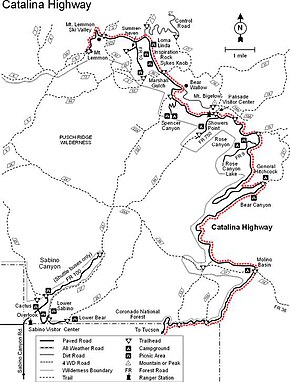
The Catalina Highway, officially the General Hitchcock Highway, is the popular name for a Forest Highway and scenic route located in Pima County in southern Arizona. Also known as the Sky Island Scenic Byway, the Mount Lemmon Highway and Arizona Forest Highway 39, the Catalina Highway is the only paved roadway providing access to the resort village of Summerhaven as well as various recreational and scientific facilities located near the summit of Mount Lemmon. Ascending from the desert floor in Tucson to near the summit of Mount Lemmon, the short highway gains over 6,000 ft (1.8 km), showcasing a variety of climates ranging from lowland desert to alpine forests. The name sky island comes from the analogy of these mountains being like islands of forest in a sea of desert. It is designated as a scenic byway by the National Scenic Byways Program. and an Arizona Scenic Road by the Federal Highway Administration.
The Catalina Highway begins at its intersection with Tanque Verde Road in northeast Tucson, traversing the unincorporated community of Tanque Verde before crossing into the Coronado National Forest. At this point, the roadway officially becomes the General Hitchcock Highway (Arizona Forest Highway 39), although many maps reflect the common usage of "Catalina Highway" to refer to the entire roadway.
From the boundary with the National Forest, the highway takes a winding route through the Santa Catalina Mountains by way of Molino Canyon. Due to the rapid gain in elevation there are numerous switchbacks, but the road follows a generally northward direction until reaching Forest Road 9 and Rose Canyon Lake, after which it begins traveling in a generally northwestern direction to the village of Summerhaven.
The final segment of the road, sometimes signed as Ski Run Road, heads east to the Mount Lemmon Ski Valley and ultimately approaches its final terminus near the summit of Mount Lemmon.
...
Wikipedia
