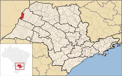
Castilho
| Castilho | |
|---|---|
| Municipality | |
 Location in São Paulo state |
|
| Location in Brazil | |
| Coordinates: 20°52′20″S 51°29′15″W / 20.87222°S 51.48750°WCoordinates: 20°52′20″S 51°29′15″W / 20.87222°S 51.48750°W | |
| Country |
|
| Region | Southeast Region |
| State | São Paulo |
| Area | |
| • Total | 1,065 km2 (411 sq mi) |
| Population (2015) | |
| • Total | 19,873 |
| • Density | 19/km2 (48/sq mi) |
| Time zone | BRT/BRST (UTC-3/-2) |
Castilho [kas.ˈti.ʎu] is a municipality in the state of São Paulo in Brazil. The population is 19,873 (2015 est.) in an area of 1065 km². The elevation is 365 m.
The municipality contains 2.57% of the 90.44 square kilometres (34.92 sq mi) Aguapeí State Park, created in 1998. It contains part of the 8,885 hectares (21,960 acres) Mouth of the Aguapeí Private Natural Heritage Reserve, created in 2010.
...
Wikipedia

