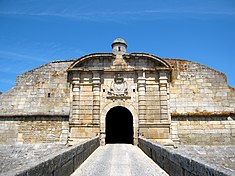
Castelo de Almeida
| Castle/Fortress of Almeida (Castelo e Fortaleza de Almeida) | |
| Walls and Square of Almeida | |
| Castle (Castelo) | |
|
The double gates of São Francisco along the walls of the star fort
|
|
| Official name: Muralhas da Praça de Almeida/Castelo e Fortaleza de Almeida | |
| Named for: Almeida | |
| Country | |
|---|---|
| Region | Norte |
| Subregion | Beira Interior Norte |
| District | Guarda |
| Municipality | Almeida |
| Location | Almeida |
| - coordinates | 40°43′32.4″N 6°54′21.5″W / 40.725667°N 6.905972°WCoordinates: 40°43′32.4″N 6°54′21.5″W / 40.725667°N 6.905972°W |
| Architects Engineers |
David Álvares, Agostinho de Andrade Freire, Anastácio António de Souza Miranda, António Carlos Andreis, António Velho de Azevedo, Casimiro José Fernandes, Fernão Teles Cotão, Francisco Gomes Chacon, Francisco Gomes de Lima, Francisco João Roscio, Francisco Maclean, Jacinto Lopes da Costa, Jerónimo Velho de Azevedo, João Alexandre de Charmont, João Victoire Aliron de Sabione, Joaquim Pedro Pinto de Sousa |
| Style | Vaubanesque Star fort |
| Materials | Masonry, Granite, Cement, Wood, Azulejo, Stone |
| Founded | 1641 |
| Owner | Portuguese Republic |
| For public | Public |
| Easiest access | Estrada Nacional E.N.340 - Almeida |
| Management | Instituto Gestão do Patrimonio Arquitectónico e Arqueológico |
| Operator | DRCCentro (Dispatch 829/2009; Diário da República, Série II, 163, 24 August 2009) |
| Hours | Castle casemates, Daily, October to March, 9:00 a.m. to 12:30 p.m. & 2:00 p.m. to 5:00 p.m./ April to September, 10:00 a.m. to 12:30 p.m. & 2:00 p.m. to 5:30 p.m. |
| Status |
Property of Public Interest Imóvel de Interesse Público |
| Listing | Decree 14/985; DG, Série I, 28 (3 February 1928); Decree 28/536; DG, Série I, 66 (22 March 1938); Special Protection Zone (ZEP), Dispatch, DG, Série II, 97, (24 April 1962) |
The Castle/Fortress of Almeida (Portuguese: Castelo e Fortaleza de Almeida) is a castle situated in the civil parish of Almeida, in the municipality of Almeida in the Portuguese district of Guarda, in the former-northwestern province of Beira Alta. It was constructed in this region due to its significant strategic importance, due to its close proximity to the border between Portugal and Spain. It is classified as a National Monument.
Portuguese settlements in the north were conveniently constructed on hilltops, providing protection to local populations from raids. During the Roman Iberian invasion/occupation many of these settlements were converted into fortified villages, due to their strategic positions. The first defensive structures were believed to be constructed by these colonists, who worked in the older castros into their fortifications.
Roman occupation of the territory was followed by successive waves of Suevi and the Visigoths who repurposed the structures. Muslim settlers, later known as Moors, occupied the settlements during the Taifa of Badajoz. The lands of Almeida were conquered from these Moors in 1039, by Ferdinand I of León and Castile, but remained contentious between 1156 and 1190, when they alternated between León, Moors and Portucalense forces. In 1190, the territory was reconquered from the Moors by Pio Guterres, named the Almeidão, effectively ending Moorish dominance in the region and inspiring the name for the village. From here the lands alternated between Leonese and Portuguese, and by 1217 Almeida was recorded as a Leonese village, part of a group of settlements that protected the Côa valley.
...
Wikipedia

